

Aisttal-Radroute 913


- culinary interesting
- culturally interesting
- Flatly
- Possible accommodation
Interactive elevation profile
Create PDF
Tour-Details
Paths covering:
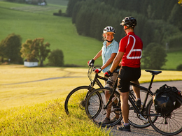
The Aisttalrunde leads from Tragwein southwards to the village of Fraundorf and on to Kriechbaum. The route continues along the Kettenbach to Hohensteg, where the Kettenbach flows into the Aist (refreshments available at Gasthaus Buchner). From there, the route continues along the Waldaisttal valley to Reichenstein, where you should definitely visit the castle ruins and the associated museum. From Reichenstein, the route continues through the natural jewel of the Waldaisttal valley to the turn-off to Erdleiten. Up to this point, the route is only slightly uphill in the Waldaisttal valley. The route from the Waldaist to Erdleiten, on the other hand, is somewhat more difficult. Over a distance of approx. 3 km, 160 metres in altitude have to be overcome. In Erdleiten you are rewarded for your efforts with a marvellous view (refreshments available at Gasthaus Ratzenböck). From Erdleiten, the route is no longer particularly strenuous back to Tragwein, where you pass the Tragwein bathing lake at the northern entrance to the village.
further information:
- culinary interesting
- Flatly
- Possible accommodation
- Board possible
by car:
Vienna: A1 - Grein - Perg - Tragwein
Linz: A7 - Unterweitersdorf - Pregarten - Tragwein
by train:
to Linz by train, from Linz by post bus to Tragwein
- Spring
- Summer
- Autumn
Please get in touch for more information.
Markt 33
4284 Tragwein
Phone +43 7263 88255
E-Mail gemeinde@tragwein.ooe.gv.at
Web www.tragwein.at/
Web www.muehlviertel-urlaub.at/rad
https://www.muehlviertel-urlaub.at/rad
")
")
")
")
")
")
")
")
")
Interactive elevation profile
Create PDF
Tour-Details
Paths covering: