

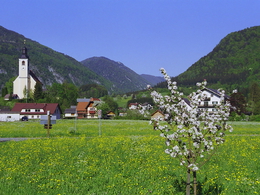
Rafter's path in Grünau in the Almtal valley


- Suitable for families
- Suitable for pushchairs
- Suitable for kids (all ages)
- Flatly
Interactive elevation profile
Create PDF
Tour-Details
Paths covering:
Hiking trail A along the Alm river.
Even in winter, this path offers a unique view of the alpine pasture.
Refreshments: Die Almwirtinnen, Forellenhof-Wieselmühle, D´Einkehr, Germdiele
further information:
- Flatly
- Board possible
")
We recommend that you travel by public transport!
Bus-train information
By train: Arrival with the Almtalbahn 153 from Wels.
by bus: OÖVV bus line 533 Gmunden - Scharnstein - Grünau im Almtal - Almsee
with the Traunstein taxi:
Route 60 from the railway station to all sights in Grünau im Almtal.
Call the taxi office 1 hour in advance on 050-422 1691 or order on the otaxi app.
by bike: on the R 11 from Wels to Grünau im Almtal
by car:
Motorway A1: Leave the Westautobahn A1 in Regau and follow the B145 to Scharnstein and Grünau im Almtal.
A9 motorway: Leave the A9 in Inzersdorf-Kirchdorf and follow the Austrian Romanikstraße to Scharnstein and Grünau im Almtal.
Please only use the parking spaces provided and be considerate of private property! Thank you for your fairness!
Free parking is available in the center of Grünau im Almtal.
- Free entry
- Suitable for groups
- Suitable for schools
- Suitable for kids (all ages)
- Suitable for pushchairs
- Suitable for families
- Suitable for couples
- Suitable for children
- Spring
- Summer
- Autumn
- Early winter
Please get in touch for more information.

Im Dorf 17
4645 Grünau im Almtal
Phone +43 7616 8286
E-Mail almtal@traunsee-almtal.at
Web www.traunsee-almtal.at
Web www.gruenau.ooe.gv.at/
http://www.gruenau.ooe.gv.at/
")
")
Interactive elevation profile
Create PDF
Tour-Details
Paths covering: