© Photo: Oberösterreich Tourismus GmbH./Robert Maybach: Enjoy the view in Upper Austria


Bogendorf-Rundweg


- Flatly
Interactive elevation profile
Create PDF
Tour-Details
Path number: H2
Starting place: 4175 Herzogsdorf
Destination: 4175 Herzogsdorf
duration: 3h 2m
length: 11,2 km
Altitude difference (uphill): 162m
Altitude difference (downhill): 174m
Lowest point: 437m
Highest point: 587m
difficulty: medium
condition: medium
panoramic view: Some Views
Paths covering:
Asphalt
powered by TOURDATA
information: Akutmeldung/Information
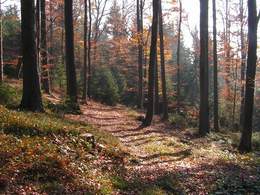
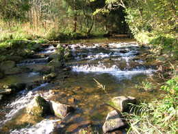
The hiking trail leads through the unspoilt Eschelbach valley to Bogendorf. Surrounded by meadows and fields, you have a marvellous panoramic view of the countryside from a small hill. The trail leads through the forest and, after crossing the Herzogsdorfer Landesstraße, leads into the "Valley of Silence". Via Zeißendorf and the Getzengraben you return to Herzogsdorf.
Most economical season
- Spring
- Summer
- Autumn
Please get in touch for more information.
Kirchenplatz 10
4175 Herzogsdorf
Phone +43 7231 2255
Fax machine +43 7231 2255 - 40
E-Mail gemeinde@herzogsdorf.ooe.gv.at
Web www.herzogsdorf.at
http://www.herzogsdorf.at
Interactive elevation profile
Create PDF
Tour-Details
Path number: H2
Starting place: 4175 Herzogsdorf
Destination: 4175 Herzogsdorf
duration: 3h 2m
length: 11,2 km
Altitude difference (uphill): 162m
Altitude difference (downhill): 174m
Lowest point: 437m
Highest point: 587m
difficulty: medium
condition: medium
panoramic view: Some Views
Paths covering:
Asphalt
powered by TOURDATA