© Photo: Oberösterreich Tourismus GmbH./Robert Maybach: Enjoy the view in Upper Austria


Rodlweg


- Flatly
Interactive elevation profile
Create PDF
Tour-Details
Path number: H4
Starting place: 4175 Herzogsdorf
Destination: 4175 Herzogsdorf
duration: 2h 28m
length: 9,3 km
Altitude difference (uphill): 110m
Altitude difference (downhill): 114m
Lowest point: 500m
Highest point: 587m
difficulty: medium
condition: medium
panoramic view: Individual Views
Paths covering:
Asphalt, Hiking trail
powered by TOURDATA
information: Akutmeldung/Information
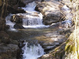
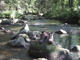
The hiking route leads from the market town car park into the Eschelbach valley, on to Freilassing and past the "Zwerchenreich" down to the Leihmühle. Here the Kleine Rodl rushes through its wild and romantic valley. The route continues downstream to Eidendorf and back to Herzogsdorf.
Most economical season
- Spring
- Summer
- Autumn
Please get in touch for more information.
Kirchenplatz 10
4175 Herzogsdorf
Phone +43 7231 2255
Fax machine +43 7231 2255 - 40
E-Mail gemeinde@herzogsdorf.ooe.gv.at
Web www.herzogsdorf.at
http://www.herzogsdorf.at
Interactive elevation profile
Create PDF
Tour-Details
Path number: H4
Starting place: 4175 Herzogsdorf
Destination: 4175 Herzogsdorf
duration: 2h 28m
length: 9,3 km
Altitude difference (uphill): 110m
Altitude difference (downhill): 114m
Lowest point: 500m
Highest point: 587m
difficulty: medium
condition: medium
panoramic view: Individual Views
Paths covering:
Asphalt, Hiking trail
powered by TOURDATA