© Photo: Oberösterreich Tourismus GmbH./Robert Maybach: Enjoy the view in Upper Austria


Altreitgrabenweg


- All weather
- Suitable for families
- Suitable for pushchairs
- Flatly
Interactive elevation profile
Create PDF
Tour-Details
Path number: H5
Starting place: 4175 Herzogsdorf
Destination: 4175 Herzogsdorf
duration: 1h 19m
length: 4,8 km
Altitude difference (uphill): 78m
Altitude difference (downhill): 78m
Lowest point: 513m
Highest point: 586m
difficulty: easy
condition: easy
panoramic view: Individual Views
Paths covering:
Asphalt
powered by TOURDATA
information: Akutmeldung/Information
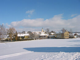
An easy circular route on paved paths, in summer and winter for strolling through the beautiful Mühlviertel countryside. Ideal as a digestive walk after a good meal.
Circular trail also suitable for children.
further information:
- Flatly
- Board possible
Details - hiking
- cleared winter hiking path
Parking
- Parking space: 30
- All weather
- Suitable for groups
- Suitable for schools
- Suitable for pushchairs
- Suitable for single travelers
- Suitable for families
- Suitable for friends
- Suitable for couples
- Suitable for children
- Spring
- Summer
- Autumn
- Early winter
- Deep winter
Please get in touch for more information.
other information
- Toilet facility for disabled people
Kirchenplatz 10
4175 Herzogsdorf
Phone +43 7231 2255
Fax machine +43 7231 2255 - 40
E-Mail gemeinde@herzogsdorf.ooe.gv.at
Web www.herzogsdorf.at
http://www.herzogsdorf.at
Interactive elevation profile
Create PDF
Tour-Details
Path number: H5
Starting place: 4175 Herzogsdorf
Destination: 4175 Herzogsdorf
duration: 1h 19m
length: 4,8 km
Altitude difference (uphill): 78m
Altitude difference (downhill): 78m
Lowest point: 513m
Highest point: 586m
difficulty: easy
condition: easy
panoramic view: Individual Views
Paths covering:
Asphalt
powered by TOURDATA