

Meditation path


- All weather
- Suitable for families
- Suitable for pushchairs
Interactive elevation profile
Create PDF
Tour-Details
Paths covering:
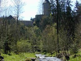
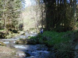
From the railway station, this lyrical trail follows the romantic Feistritz valley for approx. 2 km upstream to the reservoir and the hammer mill with haiku by the Lasberg poet Grete Burger. These haiku are nature poems which were brought back to life in 2004 by sensitive children's drawings by pupils from Lasberg primary school.
further information:
- Board possible
Possible at any time.
Attention in the winter months, no snow removal.
by car:
On the motorway to Linz, then on the Mühlkreis motorway to Unterweitersdorf and on the B 310 to Lasberg.
By train:
ÖBB train stop Lasberg/St. Oswald - 3 km from the village of Lasberg
Bus: Rather poor connection
- All weather
- Suitable for groups
- Suitable for schools
- Suitable for pushchairs
- Suitable for families
- Spring
- Summer
- Autumn
Somewhat suitable for wheelchairs: Assistance is sometimes necessary. The measurements do not (fully) conform to the legally stipulated ÖNORM.

Markt 26
4291 Lasberg
Phone +43 7947 7255 - 13
Fax machine +43 7947 7255 - 33
E-Mail tourismuskern@lasberg.at
Web www.lasberg.at
Interactive elevation profile
Create PDF
Tour-Details
Paths covering: