© Photo: Oberösterreich Tourismus GmbH./Robert Maybach: Enjoy the view in Upper Austria


H4 AGRU Runde


- Flatly
Interactive elevation profile
Create PDF
Tour-Details
Path number: H4
Starting place: 4540 Bad Hall
Destination: 4540 Bad Hall
duration: 1h 46m
length: 6,6 km
Altitude difference (uphill): 89m
Altitude difference (downhill): 91m
Lowest point: 348m
Highest point: 394m
difficulty: medium
condition: medium
panoramic view: Some Views
Paths covering:
Asphalt, Gravel
powered by TOURDATA
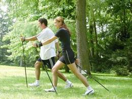
The varied "Agru loop" offers the best conditions for strengthening your basic endurance. It starts downhill to the tennis court on a paved surface to the Haller Bach stream, after a short steep descent you cross the bridge and then travel through Kleinmengersdorf in beautiful surroundings before returning to the start together with lap 5.
Most economical season
- Spring
- Summer
- Autumn
Please get in touch for more information.
Kurpromenade 1
4540 Bad Hall
Phone +43 7258 7200 - 0
E-Mail info@badhall.at
Web www.badhall.at
https://www.badhall.at
Interactive elevation profile
Create PDF
Tour-Details
Path number: H4
Starting place: 4540 Bad Hall
Destination: 4540 Bad Hall
duration: 1h 46m
length: 6,6 km
Altitude difference (uphill): 89m
Altitude difference (downhill): 91m
Lowest point: 348m
Highest point: 394m
difficulty: medium
condition: medium
panoramic view: Some Views
Paths covering:
Asphalt, Gravel
powered by TOURDATA