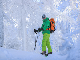
© Photo: Oberösterreich Tourismus GmbH./Robert Maybach: Enjoy the view in Upper Austria


Skitour Frauenscharte (tour area Innerrosenau)


Interactive elevation profile
Create PDF
Tour-Details
Starting place: 4581 Rosenau am Hengstpaß
Destination: 4581 Rosenau am Hengstpaß
duration: 6h 6m
length: 12,1 km
Altitude difference (uphill): 1.023m
Altitude difference (downhill): 1.015m
Lowest point: 842m
Highest point: 1.823m
difficulty: medium
condition: medium
panoramic view: Great panorama
Paths covering:
snow
powered by TOURDATA
The ski tour to the Frauenscharte leads from the Leopold in Innerrosenau over the Laglalm up to the state border.
From the parking Innerrosenau the road into the valley until you reach a sharp right curve. From here, follow the trail # 625 Laglalm direction. Now it goes straight in the flat hilly terrain along the left Mitter mountain into the valley. At the end there is a little steeper and it is left up to the saddle. From here you have a beautiful view of the Enns Valley and the Gesäuse mountains.Departure:
as the ascent
Starting point: Leopolden in Innerrosenau
Destination: Leopolden in Innerrosenau
Details - Ski
- Descent: difficulty: medium, 1000 Metres of altitude
- Snowboard suitable
Accessibility / arrival
From Windischgarsten you go to Rosenau am Hengstpass. Shortly after leaving the village take the Abwzeigung direction Innerrosenau right and drive about 3.5 km back to the parking lot.
Most economical season
- Early winter
- Deep winter
Please get in touch for more information.
Bahnhofstraße 2
4581 Rosenau am Hengstpaß
Phone +43 7562 5266
Fax machine +43 7562 5266 - 10
E-Mail info@pyhrn-priel.net
Web www.urlaubsregion-pyhrn-priel.at
https://www.urlaubsregion-pyhrn-priel.at
Interactive elevation profile
Create PDF
Tour-Details
Starting place: 4581 Rosenau am Hengstpaß
Destination: 4581 Rosenau am Hengstpaß
duration: 6h 6m
length: 12,1 km
Altitude difference (uphill): 1.023m
Altitude difference (downhill): 1.015m
Lowest point: 842m
Highest point: 1.823m
difficulty: medium
condition: medium
panoramic view: Great panorama
Paths covering:
snow
powered by TOURDATA