© Photo: Oberösterreich Tourismus GmbH./Robert Maybach: Enjoy the view in Upper Austria


Nock ski tour (tour area Sengsengebirge)


Interactive elevation profile
Create PDF
Tour-Details
Starting place: 4575 Roßleithen
Destination: 4575 Roßleithen
duration: 8h 42m
length: 12,2 km
Altitude difference (uphill): 1.585m
Altitude difference (downhill): 1.574m
Lowest point: 651m
Highest point: 1.954m
difficulty: medium
condition: medium
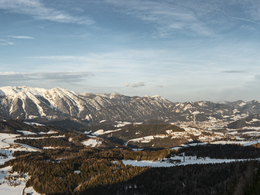
panoramic view: Great panorama
Paths covering:
snow
powered by TOURDATA
The Nock is the highest mountain of the Sengsengebirge and a tour classic with an impressive view!
From the car park follow the summer trail No. 463 first through the forest, then across a clearing until you arrive at a prominent rock wall. Here you will cross right over the sidewalk, reach the Budergraben to you. (CAUTION: When crossing there is often considerable avalanche risk!)Go to the ditch up on beautiful slopes to the saddle between Hagler and Merkenstein. Here, you take right to the foot of Gamsplans and in a large curve to the left, climb up the Southeast comb on to the summit.
Departure:
How ascent.
Starting point: Parking Rettenbach
Destination: Parking Rettenbach
Details - Ski
- Descent: difficulty: medium, 1350 Metres of altitude
Accessibility / arrival
From the motorway exit Windischgarsten you go to rading. Follow the road up to the farmhouse Rettenbach right now and continue following the road up to the cabin Rettenbach.
Most economical season
- Early winter
- Deep winter
Please get in touch for more information.
Bahnhofstraße 2
4575 Roßleithen
Phone +43 7562 5266
Fax machine +43 7562 5266 - 10
E-Mail info@pyhrn-priel.net
Web www.urlaubsregion-pyhrn-priel.at
https://www.urlaubsregion-pyhrn-priel.at
Interactive elevation profile
Create PDF
Tour-Details
Starting place: 4575 Roßleithen
Destination: 4575 Roßleithen
duration: 8h 42m
length: 12,2 km
Altitude difference (uphill): 1.585m
Altitude difference (downhill): 1.574m
Lowest point: 651m
Highest point: 1.954m
difficulty: medium
condition: medium
panoramic view: Great panorama
Paths covering:
snow
powered by TOURDATA