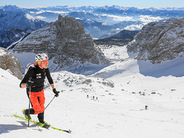
© Photo: Oberösterreich Tourismus GmbH./Robert Maybach: Enjoy the view in Upper Austria


Ski Tour of the Lower Loigistal Wurzeralm (touring area Vorderstoder)


Interactive elevation profile
Create PDF
Tour-Details
Starting place: 4582 Spital am Pyhrn
Destination: 4574 Vorderstoder
duration: 4h 26m
length: 12,0 km
Altitude difference (uphill): 374m
Altitude difference (downhill): 1.408m
Lowest point: 862m
Highest point: 2.006m
difficulty: easy
condition: easy
panoramic view: Great panorama
Paths covering:
snow
powered by TOURDATA
The classic ski tour from Frauenkar to the intermediate walls and dream exit through the lower Loigistal to Vorderstoder.
After Rossarsch, you go right into the basin upstream, between Torstein and Rossarsch for partitions Charter to 2,004 meters.
From here you can enjoy the descent through the Lower Loigistal to Schafferteich in Vorderstoder.
Starting point: Frauenkar mountain station
Destination: Parking Schafferteich Vorderstoder
Details - Ski
- Descent: difficulty: easy, 1333 Metres of altitude
- Ascent aid
Accessibility / arrival
In Spital am Pyhrn take the Wurzeralm funicular and the double chairlift Frauenkar up the mountain to the starting point.
Most economical season
- Deep winter
Please get in touch for more information.
Vorderstoder 66
4574 Vorderstoder
Phone +43 7564 8255
Fax machine +43 7564 8255 - 20
E-Mail vorderstoder@pyhrn-priel.net
Web www.urlaubsregion-pyhrn-priel.at
https://www.urlaubsregion-pyhrn-priel.at
Interactive elevation profile
Create PDF
Tour-Details
Starting place: 4582 Spital am Pyhrn
Destination: 4574 Vorderstoder
duration: 4h 26m
length: 12,0 km
Altitude difference (uphill): 374m
Altitude difference (downhill): 1.408m
Lowest point: 862m
Highest point: 2.006m
difficulty: easy
condition: easy
panoramic view: Great panorama
Paths covering:
snow
powered by TOURDATA