© Photo: Oberösterreich Tourismus GmbH./Robert Maybach: Enjoy the view in Upper Austria


Alm-Naarntal-Radroute Nr. 942


- Suitable for families
Interactive elevation profile
Create PDF
Tour-Details
Path number: 942
Starting place: 4283 Bad Zell
Destination: 4280 Königswiesen
duration: 2h 15m
length: 26,2 km
Altitude difference (uphill): 622m
Altitude difference (downhill): 557m
Lowest point: 438m
Highest point: 778m
difficulty: medium
condition: medium
panoramic view: Some Views
Paths covering:
Asphalt, Street
powered by TOURDATA
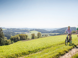
Enjoy the beautiful natural landscape between Bad Zell and Königswiesen on a trekking or e-bike. The connecting route is signposted on both sides and leads through the refreshing Naarn river valley and past the Ruttenstein castle ruins. Magnificent views also await you along the tour.
Starting point: Source of life
Destination: Marketplace
further information:
- Experience of nature
")
")
")
")
- Suitable for single travelers
- Suitable for families
- Suitable for friends
- Suitable for couples
- Spring
- Summer
- Autumn
Please get in touch for more information.
Lebensquellplatz 1
4283 Bad Zell
Phone +43 5 07263 - 0
E-Mail badzell@muehlviertel.at
Web www.kulturforum-badzell.at
Web www.muehlviertel-urlaub.at/rad
https://www.kulturforum-badzell.at
https://www.muehlviertel-urlaub.at/rad
https://www.muehlviertel-urlaub.at/rad

")
")


")
")
")
")
")

")
")


")
")
")
")
")
")

")
")
Interactive elevation profile
Create PDF
Tour-Details
Path number: 942
Starting place: 4283 Bad Zell
Destination: 4280 Königswiesen
duration: 2h 15m
length: 26,2 km
Altitude difference (uphill): 622m
Altitude difference (downhill): 557m
Lowest point: 438m
Highest point: 778m
difficulty: medium
condition: medium
panoramic view: Some Views
Paths covering:
Asphalt, Street
powered by TOURDATA