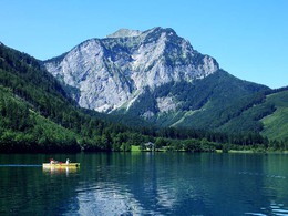
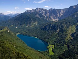
Wonderful combination of the tour with nature experiences, such as along the Langbathbach stream to the Vorderer or Hinterer Langbathsee lakes
From Ebensee town hall, the route first leads along the Langbathsee district road past the valley station of the Feuerkogel cable car. To the right, the Langbathbach babbles over small artificial cascades and provides welcome cooling. After about 4 kilometres, a forest road ("Bledistraße") branches off to the left just before a hunting lodge. After a short ascent, you reach the Vorderer Langbathsee lake on a wide, wooded valley floor against the backdrop of the northern slopes of the Höllengebirge mountains. Please drive very slowly, as many adults and children circle the lakes. Continue along the right bank of this popular excursion destination to Hinterer Langbathsee, which is a "stick" higher and is reached after a long climb. This lake with its unique view of the mighty summit cross of the Brunnkogel invites you to take a break and enjoy a refreshing footbath, as the only "mountain climb", the approximately 1 km long ascent to the Lueg (830 m), which involves a climb of 100 metres in altitude, lies ahead. The summit of the tour has been reached, from now on it's all downhill. Through a game reserve and after a short section of walking on a hiking trail, keeping to the right, you reach a forest road, which leads to the Großalm district road after a 3 km long, relaxing descent. Via Neukirchen, you roll gently downhill to Traunkirchen on tarmac roads, with the basin of Lake Traun in front of you. Along the Salzkammergut federal road B-145, you cycle from Traunkirchen to Ebensee on the cycle path. Before the ascent to the Kleiner Sonnstein, directly at the tunnel portal, you have to cross the road (be careful!!), as the cycle path continues on the left-hand side. Since the construction of three road tunnels through the Sonnstein, a long section of the old lakeside road has been reserved for bikers and walkers, allowing them to enjoy the ride along the steep banks of Lake Traunsee.
The tours presented here are suggested tours that are provided free of charge. After agreeing to the terms of the disclaimer you receive detailed information such as altitude profiles, route plans, and an option for downloading files etc.
Please click on the button "Create PDF now" to generate the document.
Loading...
Thank you for your interest, we are generating the document for you. This may take a while. Once the PDF has finished loading, it will open in a new window. The pop-up blocker of your browser should be disabled for our site.