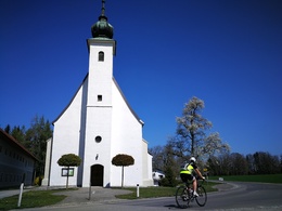
© Photo: Oberösterreich Tourismus GmbH./Robert Maybach: Enjoy the view in Upper Austria


Feichtenberg


- pets allowed
- Suitable for families
- Flatly
Interactive elevation profile
Create PDF
Tour-Details
Path number: 18
Starting place: 4655 Vorchdorf
Destination: 4655 Vorchdorf
duration: 1h 40m
length: 21,5 km
Altitude difference (uphill): 338m
Altitude difference (downhill): 332m
Lowest point: 409m
Highest point: 645m
difficulty: medium
condition: difficult
panoramic view: No view
Paths covering:
Asphalt, Gravel
powered by TOURDATA
Nice way to bike
starke Steigung) Feichtenberg – Danzlau – Heitzing – Radhaming
– Seyrkam – Eggenberg zurück ins Zentrum von Vorchdorf
- Suitable for groups
- Pets allowed
- Suitable for single travelers
- Suitable for families
- Suitable for friends
- Suitable for couples
- Spring
- Summer
- Autumn
Please get in touch for more information.

Im Dorf 17
4645 Grünau im Almtal
Phone +43 7616 8268
Fax machine +43 7616 8895
E-Mail gemeinde@vorchdorf.ooe.gv.at
Web traunsee-almtal.salzkammergut.at/
Web www.vorchdorf.at/
https://traunsee-almtal.salzkammergut.at/
https://www.vorchdorf.at/
https://www.vorchdorf.at/
Interactive elevation profile
Create PDF
Tour-Details
Path number: 18
Starting place: 4655 Vorchdorf
Destination: 4655 Vorchdorf
duration: 1h 40m
length: 21,5 km
Altitude difference (uphill): 338m
Altitude difference (downhill): 332m
Lowest point: 409m
Highest point: 645m
difficulty: medium
condition: difficult
panoramic view: No view
Paths covering:
Asphalt, Gravel
powered by TOURDATA