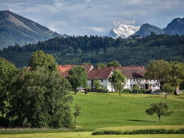
© Photo: Oberösterreich Tourismus GmbH./Robert Maybach: Enjoy the view in Upper Austria


Radweg über Bad Wimsbach


- pets allowed
- Suitable for families
- Flatly
Interactive elevation profile
Create PDF
Tour-Details
Path number: 17
Starting place: 4655 Vorchdorf
Destination: 4655 Vorchdorf
duration: 1h 30m
length: 19,1 km
Altitude difference (uphill): 145m
Altitude difference (downhill): 144m
Lowest point: 351m
Highest point: 417m
difficulty: easy
condition: easy
panoramic view: No view
Paths covering:
Asphalt, Gravel
powered by TOURDATA
Beautiful cycle path!
Bad Wimsbach back along the alpine pasture to Vorchdorf
- Suitable for groups
- Pets allowed
- Suitable for single travelers
- Suitable for families
- Suitable for friends
- Suitable for couples
- Suitable for children
- Spring
- Summer
- Autumn
- Early winter
Please get in touch for more information.

Im Dorf 17
4645 Grünau im Almtal
Phone +43 7616 8268
Fax machine +43 7616 8895
E-Mail gemeinde@vorchdorf.ooe.gv.at
Web www.traunsee-almtal.at
Web www.vorchdorf.at/
http://www.traunsee-almtal.at
https://www.vorchdorf.at/
https://www.vorchdorf.at/
Interactive elevation profile
Create PDF
Tour-Details
Path number: 17
Starting place: 4655 Vorchdorf
Destination: 4655 Vorchdorf
duration: 1h 30m
length: 19,1 km
Altitude difference (uphill): 145m
Altitude difference (downhill): 144m
Lowest point: 351m
Highest point: 417m
difficulty: easy
condition: easy
panoramic view: No view
Paths covering:
Asphalt, Gravel
powered by TOURDATA