© Photo: Oberösterreich Tourismus GmbH./Robert Maybach: Enjoy the view in Upper Austria


K1 Marterlweg


Interactive elevation profile
Create PDF
Tour-Details
Starting place: 4223 Katsdorf
Destination: 4223 Katsdorf
duration: 6h 34m
length: 23,7 km
Altitude difference (uphill): 403m
Altitude difference (downhill): 407m
Lowest point: 271m
Highest point: 429m
difficulty: easy
condition: easy
panoramic view: Individual Views
Paths covering:
Asphalt, Hiking trail
powered by TOURDATA
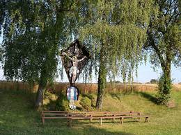
Marterlweg through the entire municipal area!
In the past, people have brought their joy and gratitude, but also their petitions and sorrow before God with the construction of shrines and chapels. In our fast-moving times, we often pass them by carelessly and forget that each of these small monuments has its own story to tell.
Starting point village square - Breitenbruck - along the district road to Bodendorf, Stadler chapel (private path), Neubodendorf - Gasser chapel - Deisinger snack station, Edtbauer chapel - Ruhstetten - Reiser (Wiesbauer cross) - Grünau - Edt - Greinsberg - Schwarzendorf - Lungitz (concentration camp memorial stone) back to Schwarzendorf (Naturfreundeweg to Katsdorf railway stop) - Neubodendorf - Katsdorf.
Most economical season
- Spring
- Summer
- Autumn
Please get in touch for more information.
Gemeindeplatz 1
4223 Katsdorf
Phone +43 7235 88155
E-Mail a.wahl@katsdorf.ooe.gv.at
Web www.katsdorf.at
http://www.katsdorf.at
Interactive elevation profile
Create PDF
Tour-Details
Starting place: 4223 Katsdorf
Destination: 4223 Katsdorf
duration: 6h 34m
length: 23,7 km
Altitude difference (uphill): 403m
Altitude difference (downhill): 407m
Lowest point: 271m
Highest point: 429m
difficulty: easy
condition: easy
panoramic view: Individual Views
Paths covering:
Asphalt, Hiking trail
powered by TOURDATA