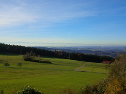
© Photo: Oberösterreich Tourismus GmbH./Robert Maybach: Enjoy the view in Upper Austria


S5 Wendenstein way


- Flatly
- Possible accommodation
Interactive elevation profile
Create PDF
Tour-Details
Path number: S5
Starting place: 4170 St. Stefan-Afiesl
Destination: 4170 St. Stefan-Afiesl
duration: 0h 51m
length: 2,8 km
Altitude difference (uphill): 81m
Altitude difference (downhill): 82m
Lowest point: 762m
Highest point: 851m
difficulty: medium
condition: medium
panoramic view: Great panorama
Paths covering:
Hiking trail
powered by TOURDATA
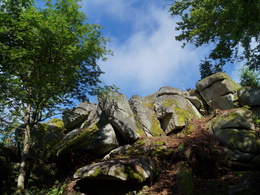
On a wonderful forest and meadow path along power stations on the Wendenstein and around the center of St. Stefan-Afiesl.
Marking: with the number S5Map download: S5 Wendenstein Weg
Starting point: St. Stefan town center
Destination: St. Stefan town center
further information:
- Flatly
- Possible accommodation
- Board possible
General price information
free
Most economical season
- Spring
- Summer
- Autumn
Please get in touch for more information.
Hauptplatz 19
4190 Bad Leonfelden
Phone +43 5 07263 - 101
Fax machine +43 7213 6397 - 13
E-Mail badleonfelden@muehlviertel.at
Web www.muehlviertel.at
https://www.muehlviertel.at
")
")
")
")
Interactive elevation profile
Create PDF
Tour-Details
Path number: S5
Starting place: 4170 St. Stefan-Afiesl
Destination: 4170 St. Stefan-Afiesl
duration: 0h 51m
length: 2,8 km
Altitude difference (uphill): 81m
Altitude difference (downhill): 82m
Lowest point: 762m
Highest point: 851m
difficulty: medium
condition: medium
panoramic view: Great panorama
Paths covering:
Hiking trail
powered by TOURDATA