© Photo: Oberösterreich Tourismus GmbH./Robert Maybach: Enjoy the view in Upper Austria


Mittelalterlicher Erlebnispfad


- pets allowed
- All weather
- Suitable for families
- Suitable for kids (all ages)
- culturally interesting
- Flatly
- Possible accommodation
Interactive elevation profile
Create PDF
Tour-Details
Starting place: 4240 Freistadt
Destination: 4240 Freistadt
duration: 7h 12m
length: 25,1 km
Altitude difference (uphill): 543m
Altitude difference (downhill): 542m
Lowest point: 518m
Highest point: 732m
difficulty: easy
condition: medium
panoramic view: Great panorama
Paths covering:
Asphalt, Gravel, Hiking trail
powered by TOURDATA
roadblock: Sperre Brücke Pührmühle
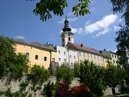
since 22.09.2024 Discover the medieval brewing town of Freistadt and explore the surrounding area.
This circular hiking trail offers a journey of discovery through Freistadt and its unspoilt surroundings, offering magnificent views of the town time and again. But it is not only the view of the medieval brewing town that makes this hike special, as the route itself also offers a wealth of exciting impressions: The Thurytal valley along the Feldaist river with the partially reactivated forge hammer mill, through forest paths up to the village of Vierzehn, many special scenic impressions, small sights such as shrines, wayside shrines and chapels, beautiful old farms, wonderful panoramic views (as far as the Ötscher and the Dachstein in appropriate weather). You can experience a few hours of peace and harmony away from everyday life.
Detailed route description under: Outdooractive.
Starting point: Hiking stone in Freistadt between Scheiblingsturm and Frauenteich
Destination: Hiking stone in Freistadt between Scheiblingsturm and Frauenteich
further information:
- Flatly
- Possible accommodation
- Board possible
Details - hiking
- themed path
- educational path

Accessibility / arrival
Park at the free car park near the Scheibling tower or at the car park in Thurytal and head north.
- Parking space: 8
- Bus parking space: 3
Free car park at the Frauenteich (Froschau 14, 4240 Freistadt)
General price information
free of charge
- All weather
- Suitable for groups
- Suitable for schools
- Suitable for kids (all ages)
- Pets allowed
- Suitable for single travelers
- Suitable for families
- Suitable for friends
- Suitable for couples
- Suitable for children
- Spring
- Summer
- Autumn
Please get in touch for more information.
other information
- Toilet facility for disabled people
Hauptplatz 1
4240 Freistadt
Phone +43 664 8325756
E-Mail office@freistadt.city
Web freistadt.city
Web www.muehlviertel-urlaub.at/wandern
https://freistadt.city
http://www.muehlviertel-urlaub.at/wandern
http://www.muehlviertel-urlaub.at/wandern
Interactive elevation profile
Create PDF
Tour-Details
Starting place: 4240 Freistadt
Destination: 4240 Freistadt
duration: 7h 12m
length: 25,1 km
Altitude difference (uphill): 543m
Altitude difference (downhill): 542m
Lowest point: 518m
Highest point: 732m
difficulty: easy
condition: medium
panoramic view: Great panorama
Paths covering:
Asphalt, Gravel, Hiking trail
powered by TOURDATA