© Photo: Oberösterreich Tourismus GmbH./Robert Maybach: Enjoy the view in Upper Austria


Themenweg G2: Stadtrundgang "Soziales Arbeiten & Leben in Gallneukirchen"


Interactive elevation profile
Create PDF
Tour-Details
Starting place: 4210 Gallneukirchen
Destination: 4210 Gallneukirchen
duration: 0h 34m
length: 2,3 km
Altitude difference (uphill): 9m
Altitude difference (downhill): 9m
Lowest point: 326m
Highest point: 343m
difficulty: very easy
condition: very easy
panoramic view: Individual Views
Paths covering:
Asphalt
powered by TOURDATA
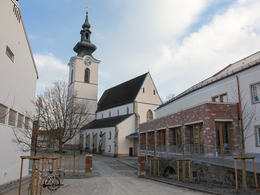
Many people spend a large part of their lives in their local community and identify with it. The Austrian social and welfare state and the commitment of citizens in associations and institutions characterise community life.
This tour of the town provides an opportunity to experience and discuss community life in Gallneukirchen as a whole.
This tour of the town provides an opportunity to experience and discuss community life in Gallneukirchen as a whole.
Starting point: Gallneukirchen Town Hall
Destination: Gallneukirchen Town Hall
Accessibility / arrival
How to get here by car:
- From Linz, take the A7 motorway to the "Gallneukirchen" exit
- Follow the road through Gallneukirchen
- After the one-way street, turn diagonally left towards "Alberndorf"
- Follow the road for approx. 7 km
Adequate free parking is available just a few metres away behind the municipal office. Turn left after the Spar supermarket onto Kalchgruberstraße, then turn right.
Travelling by bus:
- From Linz via Gallneukirchen (you may need to change buses) to "Alberndorf/Rdm. Ortsmitte"
- The bus stop is only a few metres away from the Spar supermarket.
Most economical season
- Spring
- Summer
- Autumn
Please get in touch for more information.
Reichenauer Straße 1
4210 Gallneukirchen
Phone +43 7235 63155
E-Mail stadtgemeinde@gallneukirchen.ooe.gv.at
Web www.gallneukirchen.at/STADT_er_lebe…
Web www.muehlviertel-urlaub.at/wandern
https://www.gallneukirchen.at/STADT_er_leben/Tourismus_Freizeit/Wanderwege
http://www.muehlviertel-urlaub.at/wandern
http://www.muehlviertel-urlaub.at/wandern
Interactive elevation profile
Create PDF
Tour-Details
Starting place: 4210 Gallneukirchen
Destination: 4210 Gallneukirchen
duration: 0h 34m
length: 2,3 km
Altitude difference (uphill): 9m
Altitude difference (downhill): 9m
Lowest point: 326m
Highest point: 343m
difficulty: very easy
condition: very easy
panoramic view: Individual Views
Paths covering:
Asphalt
powered by TOURDATA