© Photo: Oberösterreich Tourismus GmbH./Robert Maybach: Enjoy the view in Upper Austria


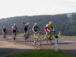
Radtour 2: Rennrad schwer


- culinary interesting
Interactive elevation profile
Create PDF
Tour-Details
Starting place: 4210 Gallneukirchen
Destination: 4210 Gallneukirchen
duration: 2h 30m
length: 46,8 km
Altitude difference (uphill): 648m
Altitude difference (downhill): 643m
Lowest point: 330m
Highest point: 862m
difficulty: difficult
condition: difficult
panoramic view: Great panorama
Paths covering:
Asphalt
powered by TOURDATA
information: Rennradtour 2 ist digital aufbereitet
Challenging tour for racing cyclists, put together and tested by former mountain bike pro Roman Rametsteiner.
With a typical Mühlviertel uphill-downhill ride, you return to the starting point via Reichenau. Towards the end of the tour, the inn in Steinbach at KM 40 in the beautiful Steinbachtal valley invites you to linger. After the rest, the remaining kilometres downhill to the Gallneukirchen market square are a breeze.
The tour is very demanding.
Starting point: Gallneukirchen marketplace
Destination: Gallneukirchen marketplace
further information:
- culinary interesting
Accessibility / arrival
How to get here by car:
- From Linz, take the A7 motorway to the "Gallneukirchen" exit
- Follow the road through Gallneukirchen
- After the one-way street, turn diagonally left towards "Alberndorf"
- Follow the road for approx. 7 km
Adequate free parking is available just a few metres away behind the municipal office. Turn left after the Spar supermarket onto Kalchgruberstraße, then turn right.
Travelling by bus:
- From Linz via Gallneukirchen (you may need to change buses) to "Alberndorf/Rdm. Ortsmitte"
- The bus stop is only a few metres away from the Spar supermarket.
Most economical season
- Spring
- Summer
- Autumn
Please get in touch for more information.

Reichenauer Straße 1
4210 Gallneukirchen
Phone +43 7235 63155
E-Mail stadtgemeinde@gallneukirchen.ooe.gv.at
Web www.gallneukirchen.at
Web www.muehlviertel-urlaub.at/rad
https://www.gallneukirchen.at
http://www.muehlviertel-urlaub.at/rad
http://www.muehlviertel-urlaub.at/rad
Interactive elevation profile
Create PDF
Tour-Details
Starting place: 4210 Gallneukirchen
Destination: 4210 Gallneukirchen
duration: 2h 30m
length: 46,8 km
Altitude difference (uphill): 648m
Altitude difference (downhill): 643m
Lowest point: 330m
Highest point: 862m
difficulty: difficult
condition: difficult
panoramic view: Great panorama
Paths covering:
Asphalt
powered by TOURDATA