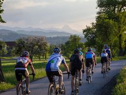
© Photo: Oberösterreich Tourismus GmbH./Robert Maybach: Enjoy the view in Upper Austria
Enjoy the view in Upper Austria
search
Search
Close

Bad Hall Rennrad Tour Frühjahrsklassiker

 Interactive elevation profile

Download GPS data
Create PDF

Tour-Details

Starting place: 4540 Bad Hall
Destination: 4540 Bad Hall

duration: 3h 0m
length: 74,0 km
Altitude difference (uphill): 644m
Altitude difference (downhill): 638m

difficulty: medium
condition: medium
panoramic view: Great panorama

Paths covering:
Asphalt, Gravel, Street

powered by TOURDATA

Half-day tour in the style of the famous spring races: Many short, sometimes steep climbs - so-called walls - and flat sections in between to "make the cut".

Once the first wall has been conquered right after the start, the route rolls over undulating terrain via Waldneukirchen to the pilgrimage town of Adlwang. After the second wall, there is a gentle climb for a panoramic ride over the ridge to the east of the Krems Valley down to the village of Siftsort. Now the third wall with the characteristic name "Tötenhengst", which is 18% steep at the top. From Kremsmünster Abbey, a few more metres uphill and then the undulating section into the Hausruckviertel as far as Schleißheim. The flat kilometres to Weißkirchen are a pleasure in a westerly wind: it rolls at over 40 km/h! To get from the Traun valley back to the Kremstal, there are a few short climbs to Neuhofen. The last of the energy is burnt on the way up to Neukematen, and the reward is a panoramic view all the way to Rohr. Then the grand finale in Bad Hall: the last wall up to the school - including a traffic light start!

Travelling by public transport
Route planner for independent travellers
  • Suitable for single travelers
Most economical season
  • Spring
  • Summer
  • Autumn

Please get in touch for more information.


Bad Hall Rennrad Tour Frühjahrsklassiker
Tourismusverband Bad Hall
4540 Bad Hall

Phone +43 7258 7200 - 0
E-Mail info@badhall.at
Web www.badhall.at
https://www.badhall.at

We speak the following languages

German

 Interactive elevation profile

Download GPS data
Create PDF

Tour-Details

Starting place: 4540 Bad Hall
Destination: 4540 Bad Hall

duration: 3h 0m
length: 74,0 km
Altitude difference (uphill): 644m
Altitude difference (downhill): 638m

difficulty: medium
condition: medium
panoramic view: Great panorama

Paths covering:
Asphalt, Gravel, Street

powered by TOURDATA