© Photo: Oberösterreich Tourismus GmbH./Robert Maybach: Enjoy the view in Upper Austria


Feuerkogel Moutainbikestrecke


Interactive elevation profile
Create PDF
Tour-Details
Starting place: 4802 Ebensee
Destination: 4802 Ebensee
duration: 2h 30m
length: 13,4 km
Altitude difference (uphill): 1.189m
Altitude difference (downhill): 80m
Lowest point: 433m
Highest point: 1.557m
difficulty: difficult
condition: difficult
panoramic view: Some Views
Paths covering:
Gravel
powered by TOURDATA
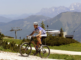
Feuerkogel mountain bike route
The rest of our route is mostly along the edge of the piste. The route, which becomes steeper and steeper in the upper section, requires a good level of fitness. A breathtaking view of the surrounding mountains awaits us at the Feuerkogel mountain station. No matter how much time it takes, the journey is the destination and you can be proud of it once you have completed it. After a visit to the hut landlord, we take the same route back to Ebensee. The difference in altitude on the Feuerkogel is a total of 1187 metres, an average biker needs around 2 to 3 hours.
Note: Biking on the Feuerkogel is only permitted on this route, all other routes are not authorised!
Accessibility / arrival
It is best to leave your car directly at the town hall square.
NOTICE TO TRAVEL: The level crossings Lahnsteinstraße, Roitherstraße and Steinkogelstraße will be closed from August 21, 07:00 am until September 01, 2023, 17:00 pm for all road users due to work on the tracks by ÖBB.
Please inform yourself online or in person about available detour options.
- Charging point for electric cars (fees apply)
- Charging point for e-bikes (free of charge)
Most economical season
- Summer
Please get in touch for more information.
4802 Ebensee
Phone +43 6133 8016
Fax machine +43 6133 8016870
E-Mail ebensee@traunsee-almtal.at
Web www.traunsee-almtal.at/ebensee
http://www.traunsee-almtal.at/ebensee
Interactive elevation profile
Create PDF
Tour-Details
Starting place: 4802 Ebensee
Destination: 4802 Ebensee
duration: 2h 30m
length: 13,4 km
Altitude difference (uphill): 1.189m
Altitude difference (downhill): 80m
Lowest point: 433m
Highest point: 1.557m
difficulty: difficult
condition: difficult
panoramic view: Some Views
Paths covering:
Gravel
powered by TOURDATA