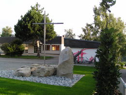
© Photo: Oberösterreich Tourismus GmbH./Robert Maybach: Enjoy the view in Upper Austria
St. Peter - Rundweg


- All weather
- Suitable for families
Interactive elevation profile
Create PDF
Tour-Details
Path number: P1
Starting place: 4171 St. Peter am Wimberg
Destination: 4171 St. Peter am Wimberg
duration: 8h 0m
length: 26,0 km
Altitude difference (uphill): 503m
Altitude difference (downhill): 497m
Lowest point: 522m
Highest point: 758m
difficulty: medium
condition: difficult
panoramic view: Great panorama
Paths covering:
Asphalt, Gravel, Hiking trail
powered by TOURDATA
Lüftnerberg-Predigtstuhl power place, Kasten school museum, Hoisnkapelle power place, St Peter's parish church and vicarage
- All weather
- Suitable for groups
- Suitable for schools
- Suitable for teenagers
- Suitable for seniors
- Suitable for single travelers
- Suitable for families
- Suitable for friends
- Suitable for couples
- Spring
- Summer
- Autumn
Please get in touch for more information.
Markt 2
4171 St. Peter am Wimberg
Phone +43 7282 8055
E-Mail gemeinde@st-peter.at
Web www.st-peter.at
http://www.st-peter.at
Interactive elevation profile
Create PDF
Tour-Details
Path number: P1
Starting place: 4171 St. Peter am Wimberg
Destination: 4171 St. Peter am Wimberg
duration: 8h 0m
length: 26,0 km
Altitude difference (uphill): 503m
Altitude difference (downhill): 497m
Lowest point: 522m
Highest point: 758m
difficulty: medium
condition: difficult
panoramic view: Great panorama
Paths covering:
Asphalt, Gravel, Hiking trail
powered by TOURDATA
