© Photo: Oberösterreich Tourismus GmbH./Robert Maybach: Enjoy the view in Upper Austria


Simader - Rundweg


- All weather
- Suitable for families
- Suitable for pushchairs
- Suitable for kids (all ages)
Interactive elevation profile
Create PDF
Tour-Details
Path number: P5
Starting place: 4171 St. Peter am Wimberg
Destination: 4171 St. Peter am Wimberg
duration: 1h 30m
length: 5,5 km
Altitude difference (uphill): 35m
Altitude difference (downhill): 38m
Lowest point: 614m
Highest point: 676m
difficulty: easy
condition: easy
panoramic view: Great panorama
Paths covering:
Asphalt, Hiking trail
powered by TOURDATA
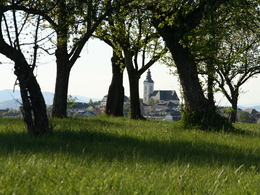
View of the main town of St. Peter and the Alps
- All weather
- Suitable for groups
- Suitable for schools
- Suitable for kids (all ages)
- Suitable for pushchairs
- Suitable for teenagers
- Suitable for seniors
- Suitable for single travelers
- Suitable for families
- Suitable for friends
- Suitable for couples
- Suitable for children
- Spring
- Summer
- Autumn
- Early winter
Suitable for wheelchairs: Not all of the legally stipulated ÖNORM are complied with. In principle, this object is suitable for wheelchairs and no assistance is necessary.
Markt 2
4171 St. Peter am Wimberg
Phone +43 7282 8055
E-Mail gemeinde@st-peter.at
Web www.st-peter.at
http://www.st-peter.at
Interactive elevation profile
Create PDF
Tour-Details
Path number: P5
Starting place: 4171 St. Peter am Wimberg
Destination: 4171 St. Peter am Wimberg
duration: 1h 30m
length: 5,5 km
Altitude difference (uphill): 35m
Altitude difference (downhill): 38m
Lowest point: 614m
Highest point: 676m
difficulty: easy
condition: easy
panoramic view: Great panorama
Paths covering:
Asphalt, Hiking trail
powered by TOURDATA