© Photo: Oberösterreich Tourismus GmbH./Robert Maybach: Enjoy the view in Upper Austria


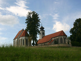
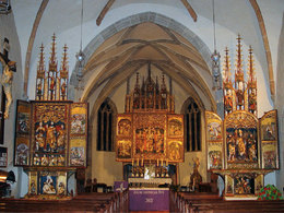
Gotikweg


- All weather
- Suitable for families
- culturally interesting
- Flatly
Interactive elevation profile
Create PDF
Tour-Details
Starting place: 4240 Freistadt
Destination: 4240 Freistadt
duration: 6h 34m
length: 22,5 km
Altitude difference (uphill): 533m
Altitude difference (downhill): 526m
Lowest point: 550m
Highest point: 790m
difficulty: medium
condition: medium
panoramic view: Great panorama
Paths covering:
Asphalt, Gravel, Hiking trail
powered by TOURDATA
This hike offers magnificent views as well as culture.
Starting point: Hiking stone on the promenade by the Scheibling tower
further information:
- Flatly
- Board possible
Details - hiking
- themed path
Accessibility / arrival
Coming from Linz, take the A7 motorway, then the B310 and then you can join the S10. Exit is Freistadt-Nord, from there you drive about 2 km back to Freistadt.
Coming from Prague on the B310 towards Freistadt.
- Parking space: 20
- Bus parking space: 2
No car park charges
- All weather
- Suitable for groups
- Suitable for schools
- Suitable for single travelers
- Suitable for families
- Suitable for friends
- Suitable for couples
- Spring
- Summer
- Autumn
Please get in touch for more information.
Hauptplatz 1
4240 Freistadt
Phone +43 664 8325756
E-Mail office@freistadt.city
Web freistadt.city
Web www.muehlviertel-urlaub.at/wandern
https://freistadt.city
http://www.muehlviertel-urlaub.at/wandern
http://www.muehlviertel-urlaub.at/wandern
Interactive elevation profile
Create PDF
Tour-Details
Starting place: 4240 Freistadt
Destination: 4240 Freistadt
duration: 6h 34m
length: 22,5 km
Altitude difference (uphill): 533m
Altitude difference (downhill): 526m
Lowest point: 550m
Highest point: 790m
difficulty: medium
condition: medium
panoramic view: Great panorama
Paths covering:
Asphalt, Gravel, Hiking trail
powered by TOURDATA