

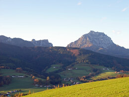
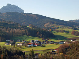
Riedl ridgeway


- Suitable for families
- Suitable for kids (all ages)
Interactive elevation profile
Create PDF
Tour-Details
Paths covering:
Beautiful circular trail in St. Konrad from Kranichsteg
sewage plant - turn right - ascent to Schobesberg - Riedl
- Oberriedel - through a forest path down to Haufenmayr - via Blasl to the Silbermair inn - via the Prielinger hiking trail - Mühlenweg - Herrnwies - back to the starting point at the Kranichsteg inn.
We recommend travelling by public transport.
by train:
Travel to either Gmunden or Scharnstein.
Gmunden: on the Westbahn line (100) to Attnang-Puchheim (ÖBB Railjet, Westbahn), change to the Salzkammergutbahn (line 170) to Gmunden station. Change to bus line 533 or Traunsee Tram to Eisengattern, change to Salzkammergut Shuttle-Service Route 52 to St. Konrad.
Scharnstein: on the Westbahn line to Wels Hbf (ÖBB and Westbahn), change to the Almtalbahn (line 153) in the direction of Grünau im Almtal "Almtalbahn" to the Scharnstein-Mühldorf stop. Change to bus line 533 or Salzkammergut Shuttle-Service Route 52 to St. Konrad.
by bus:
Bus line 533/535 Gmunden - Scharnstein - Grünau - Almsee
by Salzkammergut Shuttle-Service Route 52 Laakirchen - St. Konrad - Scharnstein
by bicycle:
Coming from Gmunden (connection to R4 Traunradweg and R2 Salzkammergut Radweg) or from Scharnstein (connection to R 11 Almtalradweg) on the Traunviertel Tour, 2nd stage. to St. Konrad.
by car:
Motorway A1 Westautobahn from Vienna Exit 207 exit Vorchdorf at the roundabout - direction Gmunden - turn off Eisengattern direction St. Konrad, approx. 13 Km.
Motorway A1 Westautobahn from Salzburg Exit 224 exit Regau - B 145 in the direction of Gmunden - before Gmunden turn onto the B 120 in the direction of Scharnstein, until St. Konrad, approx. 15 Km
- Suitable for kids (all ages)
- Suitable for teenagers
- Suitable for seniors
- Suitable for families
- Suitable for friends
- Suitable for couples
- Suitable for children
- Summer
- Autumn
Please get in touch for more information.
Ort 10
4817 St. Konrad
Phone +43 7615 8029
Fax machine +43 7615 8029 - 16
E-Mail almtal@traunsee-almtal.at
Web www.st-konrad.at/
Web traunsee-almtal.salzkammergut.at/
https://traunsee-almtal.salzkammergut.at/
Interactive elevation profile
Create PDF
Tour-Details
Paths covering: