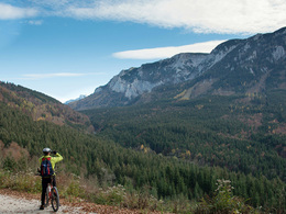
© Photo: Oberösterreich Tourismus GmbH./Robert Maybach: Enjoy the view in Upper Austria


Around the Höllengebirge - Mountainbiketour


- Flatly
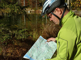
Interactive elevation profile
Create PDF
Tour-Details
Starting place: 4853 Steinbach am Attersee
Destination: 4853 Steinbach am Attersee
duration: 5h 34m
length: 64,5 km
Altitude difference (uphill): 1.535m
Altitude difference (downhill): 1.539m
Lowest point: 434m
Highest point: 906m
difficulty: medium
condition: difficult
panoramic view: Great panorama
Paths covering:
Asphalt, Hiking trail
powered by TOURDATA
Around the Höllen mountain range with the mountain bike. Either from Steinbach am Attersee or from Ebensee.
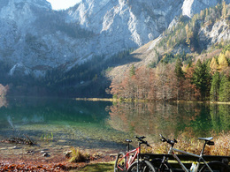
In the centre of Ebensee, we now turn left towards the Langbath lakes and reach the valley station of the Feuerkogel cable car on a slight incline. After a further 4 km on the main road, we turn left onto a gravel track, which leads us over undulating terrain to the idyllically situated Langbath lakes. The rear of the two lakes can also be circumnavigated before the first real mountain climb, the ascent to Lueg (830m), awaits us. From there, the only trail section of the tour is a short, very rocky descent (possibly pushing), followed by an enjoyable descent to the Großalm road.
Bikers with weaker fitness levels can take a shortcut from here via the Taferlklause on the main road. All others ride briefly towards Neukirchen before the signs point sharply left into the Weidensbach valley. Initially gently ascending, but then crisp and strenuous, the route climbs 300 metres in altitude on good gravel to the saddle of the Praterstern at 907 metres, the highlight of the tour. From there, the route winds down at a rapid pace to the main road and then from the Kienklause on the old country road through the wild and romantic Kienbachtal valley until we reach Lake Attersee again in Seefeld. From there it is only 1 km and a final short climb to the village centre of Steinbach.
further information:
- Flatly
details mountainbike
- Riding technique: medium
- Suitable for friends
- Spring
- Summer
- Autumn
Please get in touch for more information.
Steinbach 5
4853 Steinbach am Attersee
Phone +43 7666 7719 - 60
E-Mail info.steinbach@attersee.at
Web attersee-attergau.salzkammergut.at
https://attersee-attergau.salzkammergut.at
You can also visit us on
Visit us on Facebook Visit our videochannel on YouTube WikipediaInteractive elevation profile
Create PDF
Tour-Details
Starting place: 4853 Steinbach am Attersee
Destination: 4853 Steinbach am Attersee
duration: 5h 34m
length: 64,5 km
Altitude difference (uphill): 1.535m
Altitude difference (downhill): 1.539m
Lowest point: 434m
Highest point: 906m
difficulty: medium
condition: difficult
panoramic view: Great panorama
Paths covering:
Asphalt, Hiking trail
powered by TOURDATA