© Photo: Oberösterreich Tourismus GmbH./Robert Maybach: Enjoy the view in Upper Austria


Hydropower of yesteryear adventure trail


- pets allowed
- All weather
- Suitable for families
- Suitable for pushchairs
- Flatly
Interactive elevation profile
Create PDF
Tour-Details
Starting place: 4193 Reichenthal
Destination: 4193 Reichenthal
duration: 0h 30m
length: 1,5 km
Altitude difference (uphill): 17m
Altitude difference (downhill): 18m
Lowest point: 656m
Highest point: 674m
difficulty: very easy
condition: very easy
panoramic view: Individual Views
Paths covering:
Asphalt, Hiking trail
powered by TOURDATA
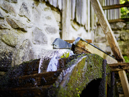
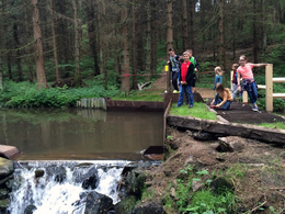
The adventure trail with a length of approx. 1.5 km lies in the middle of the wonderful nature of the Kettenbach. The tour is particularly interesting for a short trip for young or old and for families with children. Along the tour there are always interesting discoveries in the middle of nature, especially for children. A highlight along the way is the completely renovated weir system, which separates the Kettenbach and Wehrbach streams.
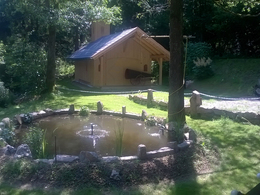
A visit to the adventure trail can be ideally combined with a tour of the mill and museum village.
Parking
- Parking space: 20
- All weather
- Suitable for schools
- Suitable for pushchairs
- Pets allowed
- Suitable for seniors
- Suitable for single travelers
- Suitable for families
- Spring
- Summer
- Autumn
Please get in touch for more information.
Hayrl 12
4193 Reichenthal
Phone +43 7214 4937
E-Mail muehlenverein@reichenthal.at
Web www.muehlenverein.at
http://www.muehlenverein.at
Interactive elevation profile
Create PDF
Tour-Details
Starting place: 4193 Reichenthal
Destination: 4193 Reichenthal
duration: 0h 30m
length: 1,5 km
Altitude difference (uphill): 17m
Altitude difference (downhill): 18m
Lowest point: 656m
Highest point: 674m
difficulty: very easy
condition: very easy
panoramic view: Individual Views
Paths covering:
Asphalt, Hiking trail
powered by TOURDATA