© Photo: Oberösterreich Tourismus GmbH./Robert Maybach: Enjoy the view in Upper Austria


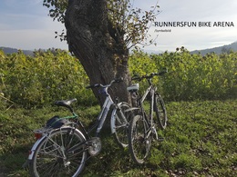
Moor-Runde by Runnersfun


- Flatly
Interactive elevation profile
Create PDF
Tour-Details
Starting place: 4654 Bad Wimsbach-Neydharting
Destination: 4654 Bad Wimsbach-Neydharting
duration: 0h 43m
length: 10,2 km
Altitude difference (uphill): 84m
Altitude difference (downhill): 84m
Lowest point: 379m
Highest point: 431m
difficulty: very easy
condition: very easy
panoramic view: Great panorama
Paths covering:
Asphalt, Gravel
powered by TOURDATA
Bewegungsarena Gesundheitsresort Bad Wimsbach - Bike route 1 - marked yellow
The starting point of the yellow Giering loop is the Neydharting moor baths. From the beginning, the hilly route runs slightly uphill on public roads past farmland through the villages of Haag and Wim. Once you reach Giering, take the 1st turn-off to the left. Slightly downhill through a short section of forest, you reach the village of Außerroh after a short climb. From here, the route leads through unspoilt forests, partly on natural ground, back to Moorbad Neydharting. Parking
- Parking space: 100
- Parking area for disabled: 3
- Suitable for seniors
- Suitable for single travelers
- Suitable for friends
- Suitable for couples
- Spring
- Summer
- Autumn
Please get in touch for more information.

Krottenseestraße 45
4810 Gmunden
Phone +43 5 028810
E-Mail office@runnersfun.com
Web www.runnersfun.com
http://www.runnersfun.com
Interactive elevation profile
Create PDF
Tour-Details
Starting place: 4654 Bad Wimsbach-Neydharting
Destination: 4654 Bad Wimsbach-Neydharting
duration: 0h 43m
length: 10,2 km
Altitude difference (uphill): 84m
Altitude difference (downhill): 84m
Lowest point: 379m
Highest point: 431m
difficulty: very easy
condition: very easy
panoramic view: Great panorama
Paths covering:
Asphalt, Gravel
powered by TOURDATA