© Photo: Oberösterreich Tourismus GmbH./Robert Maybach: Enjoy the view in Upper Austria


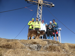
Leonsberg Mountain


Interactive elevation profile
Create PDF
Tour-Details
Starting place: 5360 St. Wolfgang im Salzkammergut
Destination: 5360 St. Wolfgang im Salzkammergut
duration: 3h 30m
length: 7,8 km
Altitude difference (uphill): 1.149m
Altitude difference (downhill): 9m
Lowest point: 558m
Highest point: 1.706m
difficulty: medium
condition: medium
panoramic view: Great panorama
Paths covering:
Gravel, Hiking trail
powered by TOURDATA
roadblock: Sperre: Leonsbergweg (Nr. 813)
since 15.10.2024 A rewarding summit tour with views of the Salzkammergut region lakes!
Start from the crossroads in Rußbach walking in the direction of Lake Schwarzensee, follow the tarmac road, then turn right towards Lake Haleswiessee, following the forest road to the fork on path no. 813. Follow this via the Rußbachalm to the Stücklalm pastures and continue to the Leonsbergalm. Then follow path no. 812 to the summit of the Leonsberg Mountain at 1,745 m. Parking
- Parking space: 2
Most economical season
- Spring
- Summer
- Autumn
Please get in touch for more information.
Au 140
5360 St. Wolfgang im Salzkammergut
Phone +43 6138 8003
E-Mail stwolfgang@wolfgangsee.at
Web www.wolfgangsee.at
http://www.wolfgangsee.at
Interactive elevation profile
Create PDF
Tour-Details
Starting place: 5360 St. Wolfgang im Salzkammergut
Destination: 5360 St. Wolfgang im Salzkammergut
duration: 3h 30m
length: 7,8 km
Altitude difference (uphill): 1.149m
Altitude difference (downhill): 9m
Lowest point: 558m
Highest point: 1.706m
difficulty: medium
condition: medium
panoramic view: Great panorama
Paths covering:
Gravel, Hiking trail
powered by TOURDATA