

Breitenberg Mountain


- Suitable for families
Interactive elevation profile
Create PDF
Tour-Details
Paths covering:
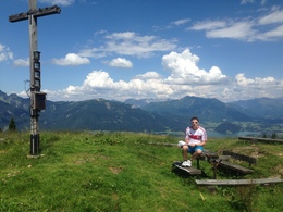
A rewarding mountain tour up the Breitenberg Mountain
From the car park, follow the forest track no. 856/857 to the Breitenberg Mountain.
A flat walk along the narrow, deeply carved valley bottom follows the beautiful Zinkenbach stream with its emerald green water. After circa one kilometre, take the right path at a fork in the road and cross over a bridge. After a clearing you reach the forest and, immediately after, the Adamalm pastures. The road curves at this point and leads once again through a wooded area to the idyllically situated Zinkenbach-Höllrin Hut. Go past this and a curve takes you back into the wood. Staying on the main path, you come to a wide forest track. The signposted path to the Breitenberg Mountain leads left here and serpentines up to the Breitenbergalm pastures. At the end, the road flattens out towards the south. At a signpost, follow the arrow in the direction of west-north-west over the meadow to the summit with its cross and bench.
- Parking space: 20
- Suitable for seniors
- Suitable for single travelers
- Suitable for families
- Suitable for friends
- Suitable for couples
- Spring
- Summer
- Autumn
Please get in touch for more information.
Mondsee Bundesstraße 1a
5342 Abersee - St. Gilgen
Phone +43 6227 2348
E-Mail stgilgen@wolfgangsee.at
Web www.wolfgangsee.at
Interactive elevation profile
Create PDF
Tour-Details
Paths covering: