

EVONIK LAP "Klimtrunde"


- All weather
- Suitable for families
- Suitable for pushchairs
- Suitable for kids (all ages)
- culturally interesting
- Flatly
Interactive elevation profile
Create PDF
Tour-Details
Paths covering:
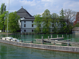
The purple "Evonik Powerrunde" is a popular and beautiful hike in the center of Schörfling. The "Klimtrunde", as it is also called, also passes nice cafés and restaurants. The starting and finishing point of the hike is the market square in Schörfling.
The "Klimtrunde", as it is also called, is an easy circular trail of 3, 14 km and 50 meters of altitude. Please always follow the violet marking!
Use at your own risk - no winter care
Refreshment stops:
- Schörfling am Attersee village center
further information:
- Flatly
all year round
ATTENTION: no winter service
Car:
From Salzburg via the A1 - exit Seewalchen
From Vienna/Linz via A1 - exit Schörfling or Seewalchen
From the west - Bad Ischl-Weißenbach-Steinbach-Weyregg-Schörfling
By train:
Coming from Salzburg or Linz/Vienna to Attnang-Puchheim or Vöcklabruck - continue with the Kammer Bahn to BH Kammer Schörfling or with the bus stop Kammer-Agerbrücke or Seewalchen-Agerbrücke.
Plane:
From Salzburg via A1 - exit Seewalchen
From Vienna/Linz via A1 - exit Schörfling or Seewalchen
Parking possibilities:
- Train station Kammer Schörfling
- Parking space: 20
- All weather
- Suitable for groups
- Suitable for schools
- Suitable for kids (all ages)
- Suitable for pushchairs
- Suitable for teenagers
- Suitable for seniors
- Suitable for single travelers
- Suitable for families
- Suitable for friends
- Suitable for couples
- Suitable for children
- Spring
- Summer
- Early winter
Please get in touch for more information.
- Toilet facility for disabled people
")
Marktplatz 22
4861 Schörfling am Attersee
mobile +43 664 5911470
E-Mail info@lc-sicking.at
Web www.lc-sicking.at
Web attersee-attergau.salzkammergut.at
https://attersee-attergau.salzkammergut.at
")
")
")
")
")
")
 (© pixabay)")
")
Interactive elevation profile
Create PDF
Tour-Details
Paths covering: