© Photo: Oberösterreich Tourismus GmbH./Robert Maybach: Enjoy the view in Upper Austria


RUNNERSFUN RUNDE "Flößerrunde"


- All weather
- Suitable for families
- culturally interesting
- Flatly
Interactive elevation profile
Create PDF
Tour-Details
Path number: S2
Starting place: 4861 Schörfling am Attersee
Destination: 4861 Schörfling am Attersee
duration: 0h 40m
length: 5,0 km
Altitude difference (uphill): 35m
Altitude difference (downhill): 34m
Lowest point: 471m
Highest point: 512m
difficulty: medium
condition: medium
panoramic view: Great panorama
Paths covering:
Asphalt, Gravel, Street, Hiking trail
powered by TOURDATA
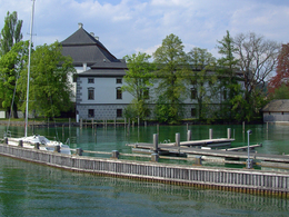
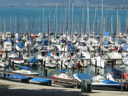
Beautiful running circuit that starts at the municipal office in Schörfling over the Marktwaldstraße verlaufent. Along surrounds a beautiful landscape, among other things, it goes along the Ager and through the Ager bridge underpass through the gorgeous castle park in Kammer!
"Flößerrunde" | medium | 6,30 km | 70 hm | marking YELLOW
Use at your own risk - no winter care
Refrehsment stopps in Schörfling am Attersee
Starting point: Municipal office
Destination: Municipal office
further information:
- Flatly
all year
Accessibility / arrival
by car:
From Salzburg via the A1 - Seewalchen exit
From Vienna/Linz via the A1 - exit Schörfling or Seewalchen
From the west - Bad Ischl-Weißenbach-Steinbach-Weyregg-Schörfling
by train:
Coming from Salzburg or Linz/Vienna to Attnang-Puchheim or Vöcklabruck - continue with the Kammer Bahn to BH Kammer Schörfling or with the bus stop Kammer-Agerbrücke or Seewalchen-Agerbrücke.
Parking lot:
Municipal office Schörfling
- Parking space: 20
- All weather
- Suitable for groups
- Suitable for schools
- Suitable for teenagers
- Suitable for seniors
- Suitable for single travelers
- Suitable for families
- Suitable for friends
- Suitable for couples
- Suitable for children
- Spring
- Summer
- Autumn
- Early winter
Please get in touch for more information.
other information
- Toilet facility for disabled people
")
Marktplatz 32
4861 Schörfling am Attersee
mobile +43 664 5911470
E-Mail info@lc-sicking.at
Web www.lc-sicking.at
Web attersee-attergau.salzkammergut.at
http://www.lc-sicking.at
https://attersee-attergau.salzkammergut.at
https://attersee-attergau.salzkammergut.at
")
")
")
")
Interactive elevation profile
Create PDF
Tour-Details
Path number: S2
Starting place: 4861 Schörfling am Attersee
Destination: 4861 Schörfling am Attersee
duration: 0h 40m
length: 5,0 km
Altitude difference (uphill): 35m
Altitude difference (downhill): 34m
Lowest point: 471m
Highest point: 512m
difficulty: medium
condition: medium
panoramic view: Great panorama
Paths covering:
Asphalt, Gravel, Street, Hiking trail
powered by TOURDATA