© Photo: Oberösterreich Tourismus GmbH./Robert Maybach: Enjoy the view in Upper Austria


Karst- & Dolinen-Erlebnisweg Feuerkogel


- Flatly
- Possible accommodation
Interactive elevation profile
Create PDF
Tour-Details
Starting place: 4802 Ebensee
Destination: 4802 Ebensee
duration: 1h 10m
length: 3,3 km
Altitude difference (uphill): 172m
Altitude difference (downhill): 171m
Lowest point: 1.524m
Highest point: 1.610m
difficulty: medium
condition: medium
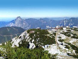
panoramic view: Great panorama
Paths covering:
Path / trail, Gravel, Hiking trail, Other
powered by TOURDATA
Walk with gorgeous view and high interesting boards
Along marvelous viewpoints, Latschen (= a special alpine vegetation, mountain pines) alleys, imposing formation of stones and relics from the ice age - guests will get on information boards a lot of knowledge to the geological history of the 'Höllengebirge', the emergence of karst rock formation and approximate 900 meters deep 'Dolinen' (= cave like a chimney).
Highlight is the new Latschen maze with its winding paths and peaceful rest places, a highlight for the whole family.
Duration of the walk: about 1 ½ hours. www.feuerkogel.info
Most economical season
- Spring
- Summer
- Autumn
Please get in touch for more information.
Hauptstraße 34
4802 Ebensee
Phone +43 6133 8016
Fax machine +43 6133 8016 - 870
E-Mail ebensee@traunsee.at
Web www.ebensee.com
Web www.feuerkogel.net
http://www.ebensee.com
http://www.feuerkogel.net
http://www.feuerkogel.net
Interactive elevation profile
Create PDF
Tour-Details
Starting place: 4802 Ebensee
Destination: 4802 Ebensee
duration: 1h 10m
length: 3,3 km
Altitude difference (uphill): 172m
Altitude difference (downhill): 171m
Lowest point: 1.524m
Highest point: 1.610m
difficulty: medium
condition: medium
panoramic view: Great panorama
Paths covering:
Path / trail, Gravel, Hiking trail, Other
powered by TOURDATA