© Photo: Oberösterreich Tourismus GmbH./Robert Maybach: Enjoy the view in Upper Austria


Dorneralm


Interactive elevation profile
Create PDF
Tour-Details
Path number: Nr. 23
Starting place: 5360 St. Wolfgang im Salzkammergut
Destination: 5360 St. Wolfgang im Salzkammergut
duration: 3h 30m
length: 7,6 km
Altitude difference (uphill): 1.271m
Altitude difference (downhill): 132m
Lowest point: 567m
Highest point: 1.758m
difficulty: medium
condition: medium
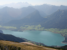
panoramic view: Dreamtour
Paths covering:
Hiking trail
powered by TOURDATA
Start: St. Wolfgang market square.
Through Florianigasse and then Kalvarienbergweg to the first chapel. Now left up steps, then keeping left on a ridge and down steps to a road junction. Beyond, turn left on a path (path sign) to the Aschinger snack station. Return via the access road to the village of Ried and keep left through the Sternallee and Pilgerstraße back to the market square.
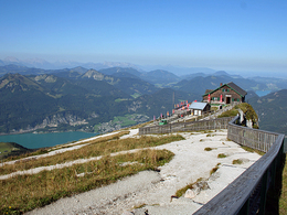
If you want to continue to the Dorneralm, follow the signs in the direction of the Schafbergalm. (path No. 23) and after a one hour ascent you will reach the alpine pasture with a beautiful views. The way back is the same.
Through Florianigasse and then Kalvarienbergweg to the first chapel. Now left up steps, then keeping left on a ridge and down steps to a road junction. Beyond, turn left on a path (path sign) to the Aschinger snack station. Return via the access road to the village of Ried and keep left through the Sternallee and Pilgerstraße back to the market square.
If you want to continue to the Dorneralm, follow the signs in the direction of the Schafbergalm. (path No. 23) and after a one hour ascent you will reach the alpine pasture with a beautiful views. The way back is the same.
Starting point: Market square St. Wolfgang
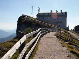
Destination: Dorneralm
Parking
- Parking space: 100
- Suitable for kids (10 - 14 Year)
- Suitable for teenagers
- Suitable for seniors
- Suitable for single travelers
- Suitable for friends
- Suitable for couples
- Suitable for children
- Spring
- Summer
- Autumn
Please get in touch for more information.
Au 140
5360 St. Wolfgang im Salzkammergut
Phone +43 6138 8003
E-Mail info@wolfgangsee.at
Web www.wolfgangsee.at
http://www.wolfgangsee.at
Interactive elevation profile
Create PDF
Tour-Details
Path number: Nr. 23
Starting place: 5360 St. Wolfgang im Salzkammergut
Destination: 5360 St. Wolfgang im Salzkammergut
duration: 3h 30m
length: 7,6 km
Altitude difference (uphill): 1.271m
Altitude difference (downhill): 132m
Lowest point: 567m
Highest point: 1.758m
difficulty: medium
condition: medium
panoramic view: Dreamtour
Paths covering:
Hiking trail
powered by TOURDATA