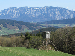
© Photo: Oberösterreich Tourismus GmbH./Robert Maybach: Enjoy the view in Upper Austria


Orte des Glaubens: Entdeckungsrunden am Mondseeberg


- pets allowed
- All weather
- Suitable for families
- Suitable for pushchairs
- Flatly
Interactive elevation profile
Create PDF
Tour-Details
Path number: 6
Starting place: 5310 Tiefgraben am Mondsee
Destination: 5310 Tiefgraben am Mondsee
duration: 3h 51m
length: 13,1 km
Altitude difference (uphill): 322m
Altitude difference (downhill): 318m
Lowest point: 780m
Highest point: 952m
difficulty: medium
condition: medium
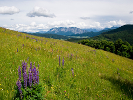
panoramic view: Individual Views
Paths covering:
Asphalt, Gravel
powered by TOURDATA
A beautiful forest hike on the Mondsee's local mountain, the Mondseeberg, with a few variations and a detour to the panoramic Hochalm.
Grubinger-Marterl (Pos. 79) and Mirl-Bild (Pos. 80) can be visited as a detour from the main circuit or as a separate circuit. The path to the Mirl-Bild (Pos. 80) is not marked from the forest road and is difficult to find. The easiest way to get there is from Powang (Krötenmühle) along the Spranzelbach, past the Spranzelbachstube and back along the same path.
further information:
- Flatly
Details - hiking
- themed path
")
")
")
")
")
")
")
")
")
")
Parking
- Parking space: 5
- All weather
- Suitable for groups
- Suitable for schools
- Suitable for pushchairs
- Pets allowed
- Suitable for teenagers
- Suitable for seniors
- Suitable for single travelers
- Suitable for families
- Suitable for friends
- Suitable for couples
- Spring
- Summer
- Autumn
- Early winter
Somewhat suitable for wheelchairs: Assistance is sometimes necessary. The measurements do not (fully) conform to the legally stipulated ÖNORM.
further information for handicapped people
Basically, the entire hike leads on forest roads, but with climbs. The length of the circular route should not be underestimated for wheelchairs.
Kirchengasse 1
5310 Tiefgraben am Mondsee
Phone +43 6232 4166
E-Mail pfarre.mondsee@dioezese-linz.at
Web www.dioezese-linz.at/mondsee
https://www.dioezese-linz.at/mondsee
Interactive elevation profile
Create PDF
Tour-Details
Path number: 6
Starting place: 5310 Tiefgraben am Mondsee
Destination: 5310 Tiefgraben am Mondsee
duration: 3h 51m
length: 13,1 km
Altitude difference (uphill): 322m
Altitude difference (downhill): 318m
Lowest point: 780m
Highest point: 952m
difficulty: medium
condition: medium
panoramic view: Individual Views
Paths covering:
Asphalt, Gravel
powered by TOURDATA