

Wildkar via ferrata


Interactive elevation profile
Create PDF
Tour-Details
Paths covering:
The via ferrata "Wildkar" was built by none less then Toni Rosifka, the owner of the Simony hut. The route itself proceeds directly over the pillar of the "vordere Niederes Kreuz" and is a wonderful finish of all the via ferratas surrounding the Simony hut.
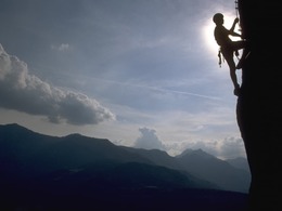
High-alpine via ferrata in the Dachstein mountains
After a rather easy start through a shallow gully (B), the climb quickly becomes more difficult (C). After a short easy section (A/B), the key section is reached, an upswing with few steps (first C/D, then D). Easier terrain (B) leads to an overhang (C/D). This is followed by the key section of the Wildkar via ferrata, the pillar (C/D) secured with numerous pins. After this, the terrain recedes and becomes much easier (first C, then B and A/B). This is followed by a short challenging section (D) before the difficulties are finally over. The rest of the route mostly runs directly along the ridge and is only partially insured (A to B).
In emergencies, call the mountain rescue service on 140
Download now: via ferrata guide for the villages of Bad Goisern, Gosau, Hallstatt and Obertraun.
Experience a 360° panoramic tour on the Dachstein Krippenstein....
Details - climbing mount
- duration hop on: 6 h
- duration climbing mount: 1 h
- duration Descent: 5 h
By car
From Salzburg:
Bundesstraße B158 towards Bad Ischl
In Bad Ischl take the exit onto Salzkammergut Straße B145 towards Bad Goisern, Hallstatt and Obertraun
From Linz:
A1 motorway exit Regau onto Salzkammergut Straße B145 towards Gmunden, Bad Goisern, Hallstatt and Obertraun
From Graz:
A9 motorway exit Liezen onto B320
In Trautenfels turn onto Salzkammergut road B145 via Bad Aussee to Obertraun
From Villach:
A10 Tauern motorway to exit "Eben im Pongau", from there via Annaberg, Gosau and Hallstatt to Obertraun
If you want to take the cable car up, continue from Hallstatt to Obertraun - district Winkl. Turn right before the Traun bridge and drive to the valley station of the Krippensteinbahn.
By bus:
to the "Obertraun-Feriendorf" stop and then walk 100 metres to the lido
By train:
from Linz/Salzburg to Attnang-Puchheim, change to the train to Stainach-Irdning
or from Stainach-Irdning train towards Attnang-Puchheim
get off at the "Obertraun-Dachsteinhöhlen" train station, from there approx. 1.4 km walk
For detailed information on the respective train and bus times, please visit http://www.oebb.at (train) and www.postbus.at (Postbus)
- Parking space: 200
- Parking area for disabled: 5
- Bus parking space: 12
- Spring
- Summer
- Autumn
Please get in touch for more information.
")
4830 Hallstatt
Phone +43 6135 6058
E-Mail office@outdoor-leadership.com
Web www.dachstein-salzkammergut.at
Web www.outdoor-leadership.com/
https://www.outdoor-leadership.com/
You can also visit us on
Visit us on Facebook Visit us on Instagram Visit us on Pinterest Visit our videochannel on YouTube WikipediaInteractive elevation profile
Create PDF
Tour-Details
Paths covering: