© Photo: Oberösterreich Tourismus GmbH./Robert Maybach: Enjoy the view in Upper Austria


TURM RUNDE | Bewegungs-Arena INNVIERTEL


- Suitable for families
- Flatly
Interactive elevation profile
Create PDF
Tour-Details
Starting place: 4923 Lohnsburg am Kobernaußerwald
Destination: 4923 Lohnsburg am Kobernaußerwald
duration: 1h 57m
length: 7,1 km
Altitude difference (uphill): 114m
Altitude difference (downhill): 122m
Lowest point: 642m
Highest point: 769m
difficulty: easy
condition: easy
panoramic view: Some Views
Paths covering:
Hiking trail
powered by TOURDATA
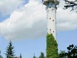
It goes briefly along the road L508. At the wind turbine, the route then leads along the Haweg forest path down through the forest to the Riedlbach. A flat and not very strenuous stretch follows in the Riedlbachtal and then it goes uphill towards Wirmling. At the apex, via the Marienweg, it then goes back to the starting point at the Turmwirt inn, where you can stop for refreshments and visit the observation tower.
Relaxliege
- Suitable for groups
- Suitable for teenagers
- Suitable for seniors
- Suitable for single travelers
- Suitable for families
- Suitable for friends
- Suitable for couples
- Spring
- Summer
- Autumn
- Early winter
Please get in touch for more information.
4923 Lohnsburg am Kobernaußerwald
Phone +43 7754 4110
E-Mail gemeinde@lohnsburg.at
Web lohnsburg.at
https://lohnsburg.at
You can also visit us on
Visit us on Facebook")
")
Interactive elevation profile
Create PDF
Tour-Details
Starting place: 4923 Lohnsburg am Kobernaußerwald
Destination: 4923 Lohnsburg am Kobernaußerwald
duration: 1h 57m
length: 7,1 km
Altitude difference (uphill): 114m
Altitude difference (downhill): 122m
Lowest point: 642m
Highest point: 769m
difficulty: easy
condition: easy
panoramic view: Some Views
Paths covering:
Hiking trail
powered by TOURDATA