© Photo: Oberösterreich Tourismus GmbH./Robert Maybach: Enjoy the view in Upper Austria


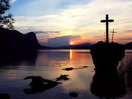
Orte des Glaubens: Am Ufer des Mondsees zum Kreuz im See


- All weather
- Suitable for families
- culturally interesting
- Flatly
Interactive elevation profile
Create PDF
Tour-Details
Path number: 28
Starting place: 5310 St. Lorenz am Mondsee
Destination: 5310 St. Lorenz am Mondsee
duration: 3h 37m
length: 12,8 km
Altitude difference (uphill): 252m
Altitude difference (downhill): 249m
Lowest point: 481m
Highest point: 618m
difficulty: medium
condition: medium
panoramic view: Some Views
Paths covering:
Asphalt, Gravel
powered by TOURDATA
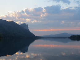
Hike- or Biketour at the lakeside of lake Mondsee.
The places of belief at the lake are located next to the federal road. It is recommended to explore this part by bike, as a cycle path is available most of the time. There is no hiking trail in this area. Likewise, the objects in Scharfling are accessible by bike, although on the "Old Scharfling Road" most will push their bike, the descent back to Mondseeufer compensates for the effort.
Starting point: Start and end is at the free public car park of the company Treml in the village Plomberg.
Destination: Start and end is at the free public car park of the company Treml in the village Plomberg.
further information:
- Flatly
")
")
")
")
")
")
")
")
")
")
")
")
")
Parking
- Parking space: 5
- All weather
- Suitable for groups
- Suitable for teenagers
- Suitable for single travelers
- Suitable for families
- Suitable for friends
- Suitable for couples
- Spring
- Summer
- Autumn
- Early winter
Please get in touch for more information.
Kirchengasse 1
5310 Mondsee am Mondsee
Phone +43 6232 4166
E-Mail pfarre.mondsee@dioezese-linz.at
Web www.dioezese-linz.at/mondsee
https://www.dioezese-linz.at/mondsee
Interactive elevation profile
Create PDF
Tour-Details
Path number: 28
Starting place: 5310 St. Lorenz am Mondsee
Destination: 5310 St. Lorenz am Mondsee
duration: 3h 37m
length: 12,8 km
Altitude difference (uphill): 252m
Altitude difference (downhill): 249m
Lowest point: 481m
Highest point: 618m
difficulty: medium
condition: medium
panoramic view: Some Views
Paths covering:
Asphalt, Gravel
powered by TOURDATA