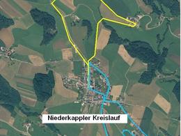
Digestion round
Starting place: 4133 Niederkappel
Destination: 4133 Niederkappel
Hauptstraße 12
4133 Niederkappel
4133 Niederkappel

Hiking route around Niederkappel - nature and adventure
The approx. 2.4 km long route leads along paved paths around Niederkappel and offers beautiful views of the village. A highlight is the "Gstoanart" leisure centre with its popular playground.
Playground in the "Gstoanart" leisure park
The playground offers children a play tower with slide, a climbing carousel, a low ropes course and crawling tunnels. A fire pit, wooden loungers and a picnic area invite young people and adults to linger.
Enjoy nature, exercise and community!
Starting point/finishing point - Niederkappel town squareMarking: Orange arrows no. 2
Starting place: 4133 Niederkappel
Destination: 4133 Niederkappel
duration: 1h 0m
length: 2,4 km
Altitude difference (uphill): 46m
Altitude difference (downhill): 46m
Lowest point: 515m
Highest point: 550m
difficulty: very easy
condition: very easy
panoramic view: Individual Views
Paths covering:
Street, Hiking trail
Starting point: Niederkappel town square
Destination: Niederkappel town square
Accessibility / arrival Car: from Linz on the B127 to the Altenfelden roundabout, turn off to Lembach im Mühlkreis, follow the road to Niederkappel
Accessibility/Arrival
Car: from Linz on the B127 to the Altenfelden roundabout, turn off to Lembach im Mühlkreis, follow the road to Niederkappel
Bus: can be reached from Linz by public bus in a good 1 hour.
Train: with the Mühlkreisbahn railway to Neufelden station - by taxi or bus to Niederkappel
Nearest airport: Linz/Hörsching
Barge: to Obermühl an der Donau - 6 km away by taxi to Niederkappel
Most economical season
- Spring
- Summer
- Autumn
- Early winter
Please get in touch for more information.
Hauptstraße 12
4133 Niederkappel
Phone +43 7286 8555
Fax machine +43 7286 8555 - 30
E-Mail gemeinde@niederkappel.at
Web www.niederkappel.at
https://www.niederkappel.at


