© Photo: Oberösterreich Tourismus GmbH./Robert Maybach: Enjoy the view in Upper Austria


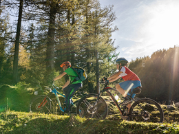
Pantl mountainbike round MTB10


- Flatly
- Possible accommodation
Interactive elevation profile
Create PDF
Tour-Details
Path number: MTB 10
Starting place: 4582 Spital am Pyhrn
Destination: 4582 Spital am Pyhrn
duration: 2h 17m
length: 17,3 km
Altitude difference (uphill): 650m
Altitude difference (downhill): 650m
Lowest point: 655m
Highest point: 1.221m
difficulty: medium
condition: medium
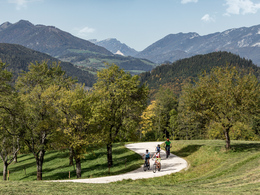
panoramic view: Great panorama
Paths covering:
Asphalt, Gravel, Other
powered by TOURDATA
The Pantl mountain bike tour leads to Oberweng and offers dream views and also a connection to the Oberwenger panorama tour (MTB2).
Now follow the road which leads past the Pantl spring, where the Spital drinking water supply originates. Shortly after the spring, turn left past the barrier. Now the forest road leads uphill with great views to the Sonnleitner gravel pit. Here the route joins the Oberwenger Panoramarunde. Follow the forest road downhill to the right to the Holzeralm.
Hiking suggestion for the combined tour: lock your bike at a bike stand and hike to the beautifully situated Gowilalm at 1,375m. Walking time to the hut approx. 45 min. on trail no. 618.
Mountain biking is expressly prohibited on the trails to the Gowilalm!
From the Holzeralm, the forest road begins with a steady, 1 km long ascent to the intersection of the forest road and the Gowilalm trail at 1,180m above sea level. On this stretch of road you have a wonderful view down into the unspoilt Goslitztal valley and a magnificent view of the Tote Gebirge, the Warscheneck and the Prielgruppe. Crossroads to the left, downhill on the Gowilalmweg. Watch out hikers! Continue to the fork in the road, turn slightly right along the beginning of the forest road to another fork in the road, straight ahead along an approx. 20m long forest path to the next forest road, descending in two hairpin bends to the forest barrier. Continue on a slightly descending forest road through pastureland to the junction with the tarmac Goslitzerstraße. Pass the Singerskogel holiday farm and descend approx. 500 m to the road junction at the Flinderlmühle. Initially flat, later slightly descending, you return to the starting point in Spital am Pyhrn via Oberweng.
Starting point: Parking lot at the indoor swimming pool in Spital am Pyhrn
Destination: Parking lot at the indoor swimming pool in Spital am Pyhrn
further information:
- Flatly
- Possible accommodation
- Board possible
details mountainbike
- Riding technique: medium
Cycling and mountain biking is allowed from April 15th to October 31st 2 hours after sunrise to 1 hour before sunset and is only allowed on marked routes. Some bike paths are also designated as hiking trails or riding trails. Always count on oncoming hikers or riders!
Accessibility / arrival
From the motorway exit (A9) Spital am Pyhrn, turn left onto the B138 into the village of Spital am Pyhrn. The start and end point is at the indoor swimming pool in Spital am Pyhrn.
- Suitable for groups
- Suitable for teenagers
- Suitable for seniors
- Suitable for single travelers
- Suitable for friends
- Suitable for couples
- Spring
- Summer
- Autumn
Please get in touch for more information.

Stiftsplatz 1
4582 Spital am Pyhrn
Phone +43 7563 249
Fax machine +43 7563 249 - 20
E-Mail spital@pyhrn-priel.net
Web www.urlaubsregion-pyhrn-priel.at
https://www.urlaubsregion-pyhrn-priel.at
")
")
")
")

")
")
")
Interactive elevation profile
Create PDF
Tour-Details
Path number: MTB 10
Starting place: 4582 Spital am Pyhrn
Destination: 4582 Spital am Pyhrn
duration: 2h 17m
length: 17,3 km
Altitude difference (uphill): 650m
Altitude difference (downhill): 650m
Lowest point: 655m
Highest point: 1.221m
difficulty: medium
condition: medium
panoramic view: Great panorama
Paths covering:
Asphalt, Gravel, Other
powered by TOURDATA