© Photo: Oberösterreich Tourismus GmbH./Robert Maybach: Enjoy the view in Upper Austria


Naturerlebnis Schottergrube - Rundweg groß


- All weather
- Suitable for families
- Suitable for pushchairs
- Suitable for kids (all ages)
- Flatly
Interactive elevation profile
Create PDF
Tour-Details
Starting place: 4846 Redlham
Destination: 4846 Redlham
duration: 1h 22m
length: 5,4 km
Altitude difference (uphill): 41m
Altitude difference (downhill): 48m
Lowest point: 377m
Highest point: 406m
difficulty: easy
condition: easy
panoramic view: No view
Paths covering:
Hiking trail, Other
powered by TOURDATA
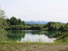
When humans change the landscape, they often create new habitats for plants and animals. Intensive gravel extraction has created such new natural areas in Redlham, artificial lakes where life has colonised.
further information:
- Flatly
Details - hiking
- themed path
- All weather
- Suitable for groups
- Suitable for kids (all ages)
- Suitable for pushchairs
- Suitable for families
- Suitable for children
- Spring
- Summer
- Autumn
- Early winter
Please get in touch for more information.
Redlham 1
4846 Redlham
Phone +43 7674 62279
E-Mail gemeinde@redlham.ooe.gv.at
Web www.redlham.at
http://www.redlham.at
")
Interactive elevation profile
Create PDF
Tour-Details
Starting place: 4846 Redlham
Destination: 4846 Redlham
duration: 1h 22m
length: 5,4 km
Altitude difference (uphill): 41m
Altitude difference (downhill): 48m
Lowest point: 377m
Highest point: 406m
difficulty: easy
condition: easy
panoramic view: No view
Paths covering:
Hiking trail, Other
powered by TOURDATA