© Photo: Oberösterreich Tourismus GmbH./Robert Maybach: Enjoy the view in Upper Austria


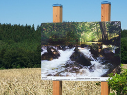
Freilichtgalerie Pilsbach


- All weather
- Suitable for pushchairs
- Suitable for kids (all ages)
- Flatly
Interactive elevation profile
Create PDF
Tour-Details
Starting place: 4840 Pilsbach
Destination: 4840 Pilsbach
duration: 0h 55m
length: 3,7 km
Altitude difference (uphill): 12m
Altitude difference (downhill): 18m
Lowest point: 458m
Highest point: 480m
difficulty: very easy
condition: easy
panoramic view: Individual Views
Paths covering:
Asphalt, Hiking trail
powered by TOURDATA
Since 2016, the small community of Pilsbach has had its own open-air photo gallery.
further information:
- Flatly
- Board possible
Details - hiking
- themed path
- All weather
- Suitable for groups
- Suitable for kids (all ages)
- Suitable for pushchairs
- Suitable for children
- Spring
- Summer
- Autumn
- Early winter
Please get in touch for more information.
Oberpilsbach 17
4840 Pilsbach
Phone +43 664 3262173
E-Mail trevor.roberts@aon.at
Web www.freilichtgalerie.com
http://www.freilichtgalerie.com
Interactive elevation profile
Create PDF
Tour-Details
Starting place: 4840 Pilsbach
Destination: 4840 Pilsbach
duration: 0h 55m
length: 3,7 km
Altitude difference (uphill): 12m
Altitude difference (downhill): 18m
Lowest point: 458m
Highest point: 480m
difficulty: very easy
condition: easy
panoramic view: Individual Views
Paths covering:
Asphalt, Hiking trail
powered by TOURDATA