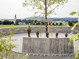
© Photo: Oberösterreich Tourismus GmbH./Robert Maybach: Enjoy the view in Upper Austria
Enjoy the view in Upper Austria
search
Search
Close

4-Kirchenweg

  • All weather
  • Suitable for pushchairs
  • Suitable for kids (all ages)
  • Flatly

 Interactive elevation profile

Download GPS data
Create PDF

Tour-Details

Starting place: 5143 Feldkirchen bei Mattighofen
Destination: 5143 Feldkirchen bei Mattighofen

duration: 4h 56m
length: 19,1 km
Altitude difference (uphill): 167m
Altitude difference (downhill): 168m

Lowest point: 486m
Highest point: 582m
difficulty: easy
condition: easy
panoramic view: Individual Views

Paths covering:
Asphalt, Waterway

powered by TOURDATA

Four churches in one parish - that is the speciality of Feldkirchen bei Mattighofen.
The 4-church trail connects these architectural jewels. Hikers should plan a walking time of five hours for the 19.4 kilometre circular route in the Oberinnviertel-Mattigtal region. There are five beautifully situated and artistically designed places to rest and linger, with sculptures pointing to the patron saint of the nearest church. Guided tours of the churches can be organised by prior arrangement.


further information:
  • Flatly
  • Board possible

Details - hiking
  • themed path
Travelling by public transport
Route planner for independent travellers
  • All weather
  • Suitable for groups
  • Suitable for kids (all ages)
  • Suitable for pushchairs
  • Suitable for children
Most economical season
  • Spring
  • Summer
  • Autumn
  • Early winter

Please get in touch for more information.


4-Kirchenweg
Dorfentwicklungsverein Feldkirchen
Feldkirchen 20
5143 Feldkirchen bei Mattighofen

Phone +43 664 2010858
E-Mail info@4-kirchenweg.at
Web www.4-kirchenweg.at
http://www.4-kirchenweg.at

We speak the following languages

German

 Interactive elevation profile

Download GPS data
Create PDF

Tour-Details

Starting place: 5143 Feldkirchen bei Mattighofen
Destination: 5143 Feldkirchen bei Mattighofen

duration: 4h 56m
length: 19,1 km
Altitude difference (uphill): 167m
Altitude difference (downhill): 168m

Lowest point: 486m
Highest point: 582m
difficulty: easy
condition: easy
panoramic view: Individual Views

Paths covering:
Asphalt, Waterway

powered by TOURDATA