

A2 Rundweg über Oberweitersdorf und Loitzendorf


- Flatly
Interactive elevation profile
Create PDF
Tour-Details
Paths covering:
Circular route from Alberndorf via Oberweitersdorf (Affenzeller whisky distillery), Loitzendorf and Pröselsdorf (Glockerwirt)
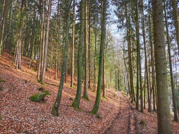
Passing a tepee village, the trail continues through the forest, across meadows, fields and the goods road to Oberweitersdorf, where a detour to the Peter Affenzeller whisky distillery (café lounge and showroom) is worthwhile.
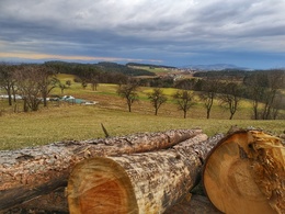
Shortly afterwards, you reach the village of Loitzendorf and thus the highest point of the hike. Here you can enjoy the marvellous view of the mountains.
After a few minutes' walk, you leave the farm track and reach Pröselsdorf. If you want to take a break, you can stop for refreshments at the Glockerwirt.
You then return to the starting point of the hike via Berbersdorf.
further information:
- Flatly
- Board possible
")

")
")
How to get there by car:
From Linz, take the A7 motorway to the "Gallneukirchen" exit
Follow the road through Gallneukirchen
After the one-way street, turn diagonally left towards "Alberndorf"
Follow the road for approx. 7 km
The start of the hiking trail is directly in front of the Spar supermarket
There is plenty of free parking just a few metres away behind the municipal office. Turn left after the Spar supermarket onto Kalchgruberstraße, then turn right.
Travelling by bus:
From Linz via Gallneukirchen (you may need to change buses) to "Alberndorf/Rdm. Ortsmitte"
The bus stop is only a few metres away from the Spar supermarket.
- Parking space: 30
- Parking area for disabled: 2
- Charging point for electric cars (fees apply)
- Charging point for e-bikes (free of charge)
- Spring
- Summer
- Autumn
- Early winter
Please get in touch for more information.
4211 Alberndorf in der Riedmark
Phone +43 7235 7155
E-Mail tourismusverband@alberndorf.ooe.gv.at
Web www.alberndorf.at
")
")
")
Interactive elevation profile
Create PDF
Tour-Details
Paths covering: