© Photo: Oberösterreich Tourismus GmbH./Robert Maybach: Enjoy the view in Upper Austria


A8 Spattendorf über Riedegg


- Flatly
Interactive elevation profile
Create PDF
Tour-Details
Path number: A8
Starting place: 4211 Alberndorf in der Riedmark
Destination: 4211 Alberndorf in der Riedmark
duration: 1h 46m
length: 6,4 km
Altitude difference (uphill): 105m
Altitude difference (downhill): 114m
Lowest point: 367m
Highest point: 480m
difficulty: very easy
condition: easy
panoramic view: Some Views
Paths covering:
Street, Hiking trail
powered by TOURDATA
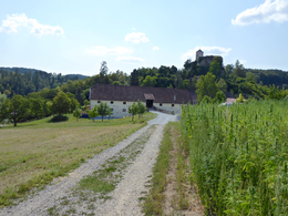
Spattendorf - Grasbach - Riedegg (detour to Riedegg Castle and castle ruins) - Grasbach - Spattendorf
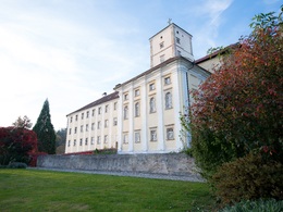
The castle was built around 1145 and has changed hands many times over the years. The castle was rebuilt in 1609 and a brick-paved equestrian staircase has been preserved in the courtyard from this period.
From the castle, follow the signposts towards Spattendorf. A dirt track leads through a farm entrance and onwards between richly cultivated fields to the forest. You walk back to the starting point via the village of Grasbach.
Starting point: Spattendorf - Grubauer Inn
Destination: Spattendorf - Grubauer Inn
further information:
- Flatly
Accessibility / arrival
How to get there by car:
From Linz, take the A7 motorway to the "Gallneukirchen" exit
Follow the road through Gallneukirchen
After the one-way street, turn diagonally left towards "Alberndorf"
Follow the road for approx. 3 km; after the "Spattendorf" sign, there is a zebra crossing, where you will find Gasthaus Grubauer.
The start of the hiking trail is at Gasthaus Grubauer, where there are also parking facilities.
Travelling by bus:
From Linz via Gallneukirchen (you may need to change buses) to "Spattendorf Ortsmitte"
The bus stop is right next to Gasthaus Grubauer.
Most economical season
- Spring
- Summer
- Autumn
- Early winter
Please get in touch for more information.
4211 Alberndorf in der Riedmark
Phone +43 7235 7155
E-Mail tourismusverband@alberndorf.ooe.gv.at
Web www.alberndorf.at/
https://www.alberndorf.at/
")
Interactive elevation profile
Create PDF
Tour-Details
Path number: A8
Starting place: 4211 Alberndorf in der Riedmark
Destination: 4211 Alberndorf in der Riedmark
duration: 1h 46m
length: 6,4 km
Altitude difference (uphill): 105m
Altitude difference (downhill): 114m
Lowest point: 367m
Highest point: 480m
difficulty: very easy
condition: easy
panoramic view: Some Views
Paths covering:
Street, Hiking trail
powered by TOURDATA