© Photo: Oberösterreich Tourismus GmbH./Robert Maybach: Enjoy the view in Upper Austria


Circular trail 3 Vöcklamarkt – Haushamerfeld – Pfaffing – Kalvarienberg


- Suitable for families
- Flatly
Interactive elevation profile
Create PDF
Tour-Details
Path number: 3
Starting place: 4870 Vöcklamarkt
Destination: 4870 Vöcklamarkt
duration: 1h 57m
length: 7,4 km
Altitude difference (uphill): 86m
Altitude difference (downhill): 83m
Lowest point: 485m
Highest point: 563m
difficulty: medium
condition: medium
panoramic view: Individual Views
Paths covering:
Gravel, Street, Hiking trail
powered by TOURDATA
Beautiful hike from Vöcklamarkt to Kalvarienberg, which takes us to the Haushamerfeld peasant war memorial, which is known far beyond the borders and refers to the peasant wars around 1625. The "Frankenburg Dice Game" is also held every two years to commemorate these tragic clashes between peasants and landlords.
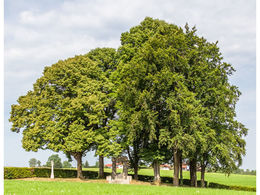
The tour starts in the municipality of Vöcklamarkt. Here, after a few forks in the path, you first cross the Vöckla and then continue over the ditch up to the "Maurachen Allee", a special kind of natural monument, and on to the Haushamerfeld.
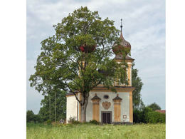
Here you will find a monument commemorating the Peasants' Wars around 1600. In memory of this tragic event the "Frankenburger Würfelspiel" takes place every 2 years, which is performed exclusively by amateur actors. The path then leads us downhill to the Pfaffing village hall, past the tennis court to Pfaffing.
Now we head up to Ziegelhaid to the Ziegelstub'n snack station. Here you have a wide panoramic view of the lake area and the Höllengebirge mountains.
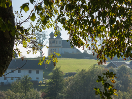
The road continues to Teicht. Here we turn left and then right again at the Vitzal snack station down the road to the Kalvarienberg. Here you have a wonderful view of Vöcklamarkt with the mountains behind it.
There are two options for the way back:
We can either hike from the Kalvarienberg chapel via the Way of the Cross down to Vöcklamarkt or back to the road and down again via Landberg, back to the starting point.
Rest stops:
Jausenstation Zieglstubn, +43 7682 22622
Jausenstation Vitzal, +43 7682 664 1850 047
The tour starts in the municipality of Vöcklamarkt. Here, after a few forks in the path, you first cross the Vöckla and then continue over the ditch up to the "Maurachen Allee", a special kind of natural monument, and on to the Haushamerfeld.
Here you will find a monument commemorating the Peasants' Wars around 1600. In memory of this tragic event the "Frankenburger Würfelspiel" takes place every 2 years, which is performed exclusively by amateur actors. The path then leads us downhill to the Pfaffing village hall, past the tennis court to Pfaffing.
Now we head up to Ziegelhaid to the Ziegelstub'n snack station. Here you have a wide panoramic view of the lake area and the Höllengebirge mountains.
The road continues to Teicht. Here we turn left and then right again at the Vitzal snack station down the road to the Kalvarienberg. Here you have a wonderful view of Vöcklamarkt with the mountains behind it.
There are two options for the way back:
We can either hike from the Kalvarienberg chapel via the Way of the Cross down to Vöcklamarkt or back to the road and down again via Landberg, back to the starting point.
Rest stops:
Jausenstation Zieglstubn, +43 7682 22622
Jausenstation Vitzal, +43 7682 664 1850 047
Accessibility / arrival
Car:
From Salzburg via the A1 - exit St. Georgen im Attergau - continue right on the Attergaustrasse L540 towards Vöcklamarkt
From Vienna/Linz via the A1 - exit St. Georgen im Attergau - continue right on the Attergaustrasse L540 towards Vöcklamarkt
From the west - Bad Ischl - Weißenbachtal (B153) - continue on the B152 to Unterach - then on the B151 to Attersee - continue on the L540 via St. Georgen im Attergau to Vöcklamarkt
Train:
From Salzburg or Linz/Vienna with the "Österreichische Bundesbahnen" or the "Westbahn" to Attnang-Puchheim, continue with the regional train to Vöcklamarkt
- Parking space: 15
- Parking area for disabled: 2
- Free entry
- Suitable for groups
- Suitable for teenagers
- Suitable for seniors
- Suitable for single travelers
- Suitable for friends
- Suitable for couples
- Suitable for children
- Spring
- Summer
- Autumn
Please get in touch for more information.
")
Dr.-Scheiber-Straße 8
4870 Vöcklamarkt
Phone +43 7682 2655
mobile +43 7666 7719
E-Mail info.nussdorf@attersee.at
Web attersee-attergau.salzkammergut.at/…
https://attersee-attergau.salzkammergut.at/oesterreich-stadt-ort/detail/430001292/voecklamarkt.html
")

")
Interactive elevation profile
Create PDF
Tour-Details
Path number: 3
Starting place: 4870 Vöcklamarkt
Destination: 4870 Vöcklamarkt
duration: 1h 57m
length: 7,4 km
Altitude difference (uphill): 86m
Altitude difference (downhill): 83m
Lowest point: 485m
Highest point: 563m
difficulty: medium
condition: medium
panoramic view: Individual Views
Paths covering:
Gravel, Street, Hiking trail
powered by TOURDATA