© Photo: Oberösterreich Tourismus GmbH./Robert Maybach: Enjoy the view in Upper Austria


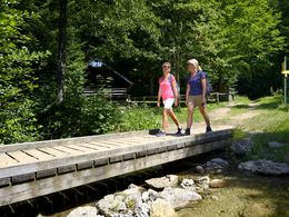
Grünberg - Laudachsee


- pets allowed
- Suitable for pushchairs
- Suitable for kids (all ages)
Interactive elevation profile
Create PDF
Tour-Details
Starting place: 4810 Gmunden
Destination: 4810 Gmunden
duration: 2h 9m
length: 6,4 km
Altitude difference (uphill): 243m
Altitude difference (downhill): 285m
Lowest point: 873m
Highest point: 966m
difficulty: very easy
condition: easy
panoramic view: Some Views
Paths covering:
Gravel, Hiking trail
powered by TOURDATA
The most beautiful hiking trails in the Salzkammergut - and all just 10 minutes from the beautiful town centre of Gmunden!
The Grünberg cable car takes you up to 1,004 metres above sea level to the popular recreational and hiking area of the Traunsee-Almtal Salzkammergut tourism association.
further information:
- Board possible
Details - hiking
- educational path
- Suitable for groups
- Suitable for schools
- Suitable for kids (all ages)
- Suitable for pushchairs
- Pets allowed
- Suitable for teenagers
- Suitable for seniors
- Suitable for single travelers
- Suitable for friends
- Suitable for couples
- Suitable for children
- Spring
- Summer
- Autumn
Not suitable for wheelchairs. The property is not compliant with Austria's ÖNORM legal standard.

Toscanapark 1
4810 Gmunden
Phone +43 7612 74451 - 17
E-Mail info@traunsee-almtal.at
Web www.traunsee-almtal.at
http://www.traunsee-almtal.at
Interactive elevation profile
Create PDF
Tour-Details
Starting place: 4810 Gmunden
Destination: 4810 Gmunden
duration: 2h 9m
length: 6,4 km
Altitude difference (uphill): 243m
Altitude difference (downhill): 285m
Lowest point: 873m
Highest point: 966m
difficulty: very easy
condition: easy
panoramic view: Some Views
Paths covering:
Gravel, Hiking trail
powered by TOURDATA