© Photo: Oberösterreich Tourismus GmbH./Robert Maybach: Enjoy the view in Upper Austria


Loipe Alberndorf - Schlammersdorf


- Flatly
Interactive elevation profile
Create PDF
Tour-Details
Starting place: 4211 Alberndorf in der Riedmark
Destination: 4211 Alberndorf in der Riedmark
duration: 0h 18m
length: 2,1 km
Altitude difference (uphill): 32m
Altitude difference (downhill): 33m
Lowest point: 546m
Highest point: 579m
difficulty: easy
condition: easy
panoramic view: Some Views
Paths covering:
snow
powered by TOURDATA
Trail not in operation
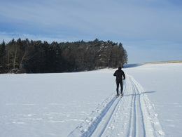
The perfectly groomed trails in and around Alberndorf invite all cross-country skiing enthusiasts as well as nature lovers to spend a few hours in the fresh air.
This trail can be used as an extension of the trail from the sports field or as a link from the sports field to the trail to Spattendorf Starting point: Start at the Schlammersdorf junction or at the sports field (combination with the sports field - Alberndorf trail)
further information:
- Flatly
Details - Trail
- Nordic skiing facilities: Marked Nordic skiing run
- Type of Nordic skiing run: Classic style
- free
Accessibility / arrival
Combination with the sports field trail: From the town centre in the direction of Wintersdorf, the sports field is located after approx. 800m on the left-hand side.
You can join the trail in Schlammersdorf at the bus stop at the Schlammersdorf turn-off just before entering Alberndorf.
Most economical season
- Deep winter
Please get in touch for more information.
Kalchgruberstraße 2
4211 Alberndorf in der Riedmark
Phone +43 7235 7155
E-Mail tourismusverband@alberndorf.ooe.gv.at
Web www.bergfex.at/oberoesterreich/lang…
https://www.bergfex.at/oberoesterreich/langlaufen/alberndorf/
Interactive elevation profile
Create PDF
Tour-Details
Starting place: 4211 Alberndorf in der Riedmark
Destination: 4211 Alberndorf in der Riedmark
duration: 0h 18m
length: 2,1 km
Altitude difference (uphill): 32m
Altitude difference (downhill): 33m
Lowest point: 546m
Highest point: 579m
difficulty: easy
condition: easy
panoramic view: Some Views
Paths covering:
snow
powered by TOURDATA