© Photo: Oberösterreich Tourismus GmbH./Robert Maybach: Enjoy the view in Upper Austria


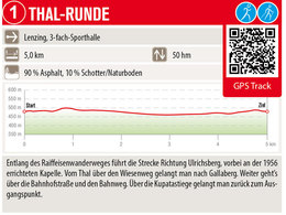
Thal-Runde


- pets allowed
- All weather
- Suitable for families
- Suitable for pushchairs
- Suitable for kids (all ages)
- Flatly
Interactive elevation profile
Create PDF
Tour-Details
Path number: 1
Starting place: 4860 Lenzing
Destination: 4860 Lenzing
duration: 1h 12m
length: 4,9 km
Altitude difference (uphill): 20m
Altitude difference (downhill): 20m
Lowest point: 461m
Highest point: 494m
difficulty: medium
condition: medium
panoramic view: Some Views
powered by TOURDATA
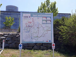
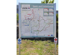
Starting point 3-fold sports hall at the school centre | 5 km | 50 hm
Parking
- Parking space: 10
- All weather
- Suitable for groups
- Suitable for schools
- Suitable for kids (all ages)
- Suitable for pushchairs
- Pets allowed
- Suitable for teenagers
- Suitable for seniors
- Suitable for single travelers
- Suitable for families
- Suitable for friends
- Suitable for couples
- Suitable for children
- Spring
- Summer
- Autumn
- Early winter
Please get in touch for more information.
")
Thal 15
4860 Lenzing
Phone +43 7672 92955 - 0
E-Mail marktgemeinde@lenzing.or.at
Web www.lenzing.ooe.gv.at
Web attersee-attergau.salzkammergut.at/
http://www.lenzing.ooe.gv.at
https://attersee-attergau.salzkammergut.at/
https://attersee-attergau.salzkammergut.at/
Interactive elevation profile
Create PDF
Tour-Details
Path number: 1
Starting place: 4860 Lenzing
Destination: 4860 Lenzing
duration: 1h 12m
length: 4,9 km
Altitude difference (uphill): 20m
Altitude difference (downhill): 20m
Lowest point: 461m
Highest point: 494m
difficulty: medium
condition: medium
panoramic view: Some Views
powered by TOURDATA