© Photo: Oberösterreich Tourismus GmbH./Robert Maybach: Enjoy the view in Upper Austria


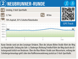
Neubrunner-Runde


- pets allowed
- All weather
- Suitable for families
- Suitable for pushchairs
- Suitable for kids (all ages)
- Flatly
Interactive elevation profile
Create PDF
Tour-Details
Path number: 2
Starting place: 4860 Lenzing
Destination: 4860 Lenzing
length: 0,0 km
Lowest point: 477m
Highest point: 477m
difficulty: easy
condition: easy
panoramic view: Some Views
powered by TOURDATA
Starting point 3-fold sports hall | 3.7 km | 40 m elevation gain | Short route around the centre of Lenzing.
Parking
- Parking space: 5
- All weather
- Suitable for groups
- Suitable for schools
- Suitable for kids (all ages)
- Suitable for pushchairs
- Pets allowed
- Suitable for seniors
- Suitable for single travelers
- Suitable for families
- Suitable for friends
- Suitable for couples
- Suitable for children
- Spring
- Summer
- Autumn
- Early winter
Somewhat suitable for wheelchairs: Assistance is sometimes necessary. The measurements do not (fully) conform to the legally stipulated ÖNORM.
")
Thal 15
4860 Lenzing
Phone +43 7672 92955 - 0
E-Mail marktgemeinde@lenzing.or.at
Web www.lenzing.ooe.gv.at
Web attersee-attergau.salzkammergut.at/
http://www.lenzing.ooe.gv.at
https://attersee-attergau.salzkammergut.at/
https://attersee-attergau.salzkammergut.at/
Interactive elevation profile
Create PDF
Tour-Details
Path number: 2
Starting place: 4860 Lenzing
Destination: 4860 Lenzing
length: 0,0 km
Lowest point: 477m
Highest point: 477m
difficulty: easy
condition: easy
panoramic view: Some Views
powered by TOURDATA